
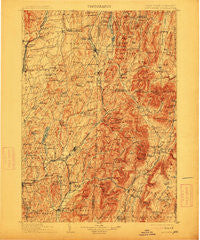
~ Mettawee VT topo map, 1:125000 scale, 30 X 30 Minute, Historical, 1903, updated 1913
Mettawee, Vermont, USGS topographic map dated 1903.
Includes geographic coordinates (latitude and longitude). This topographic map is suitable for hiking, camping, and exploring, or framing it as a wall map.
Printed on-demand using high resolution imagery, on heavy weight and acid free paper, or alternatively on a variety of synthetic materials.
Topos available on paper, Waterproof, Poly, or Tyvek. Usually shipping rolled, unless combined with other folded maps in one order.
- Product Number: USGS-5454789
- Free digital map download (high-resolution, GeoPDF): Mettawee, Vermont (file size: 10 MB)
- Map Size: please refer to the dimensions of the GeoPDF map above
- Weight (paper map): ca. 55 grams
- Map Type: POD USGS Topographic Map
- Map Series: HTMC
- Map Verison: Historical
- Cell ID: 66043
- Scan ID: 144535
- Imprint Year: 1913
- Survey Year: 1894
- Datum: Unstated
- Map Projection: Unstated
- Map published by United States Geological Survey
- Map Language: English
- Scanner Resolution: 600 dpi
- Map Cell Name: Mettawee
- Grid size: 30 X 30 Minute
- Date on map: 1903
- Map Scale: 1:125000
- Geographical region: Vermont, United States
Neighboring Maps:
All neighboring USGS topo maps are available for sale online at a variety of scales.
Spatial coverage:
Topo map Mettawee, Vermont, covers the geographical area associated the following places:
- West Granville - Salem - Fitch Point - Manchester Depot - Cambridge - East Hartford - The Plains - Beartown - Rexleigh - Bourne Brook - Dorset - Scottsville - North Cambridge - Spraguetown - Belcher - Baldwin Corner - Goose Island - Kansas - Manchester Center - Battenville - East Dorset - Truthville - Pawlet - Hillsdale - Wells - Middle Granville - North Greenwich - Comstock - Sandgate - North Granville - Freedleyville - Hartford - West Hebron - North Pawlet - Richville - Adamsville - East Hebron - North Argyle - Ash Grove - North Hebron - Pumpkin Hook - Middletown Springs - North Rupert - Ravenwood Estates - South Dorset - Raceville - Hidden Valley - North Dorset - West Arlington - West Pawlet - Chiselville - Cossayuna - Shaftsbury - Glastenbury - South Poultney - Mountain View Estates - East Greenwich - Shushan - Tinmouth - Slyboro - Burnham Hollow - Eagleville - East Wells - Butternut - West Rupert - Archdale - East Arlington - Greenwich Junction - Porter - Fly Summit - Greenwich - Sunderland - Tiplady - Fayville - Rupert - Center Falls - Fort Ann - Anaquassacook - Granville - Barnumville - MacIntyre - East Kansas - East Rupert - West Sandgate - Danby Four Corners - Argyle - Haines Manor - South Argyle - Arlington - Slateville - South Granville - West Tinmouth - Manchester - South Hartford - Coila
- Map Area ID: AREA43.543-73.5-73
- Northwest corner Lat/Long code: USGSNW43.5-73.5
- Northeast corner Lat/Long code: USGSNE43.5-73
- Southwest corner Lat/Long code: USGSSW43-73.5
- Southeast corner Lat/Long code: USGSSE43-73
- Northern map edge Latitude: 43.5
- Southern map edge Latitude: 43
- Western map edge Longitude: -73.5
- Eastern map edge Longitude: -73


