
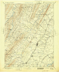
~ Winchester VA topo map, 1:125000 scale, 30 X 30 Minute, Historical, 1894, updated 1932
Winchester, Virginia, USGS topographic map dated 1894.
Includes geographic coordinates (latitude and longitude). This topographic map is suitable for hiking, camping, and exploring, or framing it as a wall map.
Printed on-demand using high resolution imagery, on heavy weight and acid free paper, or alternatively on a variety of synthetic materials.
Topos available on paper, Waterproof, Poly, or Tyvek. Usually shipping rolled, unless combined with other folded maps in one order.
- Product Number: USGS-5416178
- Free digital map download (high-resolution, GeoPDF): Winchester, Virginia (file size: 7 MB)
- Map Size: please refer to the dimensions of the GeoPDF map above
- Weight (paper map): ca. 55 grams
- Map Type: POD USGS Topographic Map
- Map Series: HTMC
- Map Verison: Historical
- Cell ID: 66958
- Scan ID: 189213
- Imprint Year: 1932
- Survey Year: 1885
- Datum: Unstated
- Map Projection: Polyconic
- Map published by United States Geological Survey
- Map Language: English
- Scanner Resolution: 600 dpi
- Map Cell Name: Winchester
- Grid size: 30 X 30 Minute
- Date on map: 1894
- Map Scale: 1:125000
- Geographical region: Virginia, United States
Neighboring Maps:
All neighboring USGS topo maps are available for sale online at a variety of scales.
Spatial coverage:
Topo map Winchester, Virginia, covers the geographical area associated the following places:
- Darkesville - Blue Ridge Mobile Home Park - Lincoln Estates - Plainfield Heights - Wheatfield - Cacapehon - Brookneil - Finger Lake Estates - Bartonsville - Wellington Acres - Bunker Hill - Day - Mar Village - Bubbling Spring - Layside Estates - Stonewall Orchard - Greenway Estates - Frederick Heights - Valley Acres - Nieswanders Fort - Mount Pleasant - Mountain Falls Park - White Post - Pyletown - Stonebrook Farms - Burning Knolls - Lebanon Church - Millwood - Klines Mill - Echo Village - Southview - Cather Estates - Reliance - Chambersville - Boyce - Rock Enon Springs - Inwood - Milldale - Jones Springs - Westwood - Keeneland - Capon Springs - Welltown - Chapel Estates - Cross Junction - Ole Orchard Estates - Wildwood Hills - Lost Corner - Woodrow - Shawnee Land - Swimley - Tarico Heights - Rolling Hills - Clary - Glengary - Arcadia Mobile Home Park - Wamplers Trailer Park - Albin - Winchester - Union Corner - Mount Hope - Vaucluse - Apple View Estates - Indian Lake - Peach Orchard Inn Farms - Dearmont Chase - Greenway Court - Bloomery - Rolling Fields - Zepp - Kernstown - Goose Nest - Brucetown - McQuire - Wadesville - Gerrardstown - Spring Valley - The Knolls - Burnt Factory - Freyco - Mosswood Hills - Green Acres - Bloom (historical) - Unger - Bunker Hill - Capon Bridge - Gordondale - Neals Run - Saratoga - Wilde Acres - Ridgeway - Keystone Estates - Grouse Hollow Estates - Oakland - Nero (historical) - High View - Hogue Creek Estates - Ganotown - Gun Barrel Lane Estates - Senseny Heights - Indian Hollow
- Map Area ID: AREA39.539-78.5-78
- Northwest corner Lat/Long code: USGSNW39.5-78.5
- Northeast corner Lat/Long code: USGSNE39.5-78
- Southwest corner Lat/Long code: USGSSW39-78.5
- Southeast corner Lat/Long code: USGSSE39-78
- Northern map edge Latitude: 39.5
- Southern map edge Latitude: 39
- Western map edge Longitude: -78.5
- Eastern map edge Longitude: -78


