
~ Ripley WV topo map, 1:100000 scale, 30 X 60 Minute, Historical, 1984, updated 1984
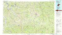
Ripley, West Virginia, USGS topographic map dated 1984.
Includes geographic coordinates (latitude and longitude). This topographic map is suitable for hiking, camping, and exploring, or framing it as a wall map.
Printed on-demand using high resolution imagery, on heavy weight and acid free paper, or alternatively on a variety of synthetic materials.
Topos available on paper, Waterproof, Poly, or Tyvek. Usually shipping rolled, unless combined with other folded maps in one order.
- Product Number: USGS-5416118
- Free digital map download (high-resolution, GeoPDF): Ripley, West Virginia (file size: 28 MB)
- Map Size: please refer to the dimensions of the GeoPDF map above
- Weight (paper map): ca. 55 grams
- Map Type: POD USGS Topographic Map
- Map Series: HTMC
- Map Verison: Historical
- Cell ID: 72191
- Scan ID: 701705
- Imprint Year: 1984
- Woodland Tint: Yes
- Edit Year: 1984
- Datum: NAD27
- Map Projection: Universal Transverse Mercator
- Map published by United States Geological Survey
- Map Language: English
- Scanner Resolution: 508 dpi
- Map Cell Name: Ripley
- Grid size: 30 X 60 Minute
- Date on map: 1984
- Map Scale: 1:100000
- Geographical region: West Virginia, United States
Neighboring Maps:
All neighboring USGS topo maps are available for sale online at a variety of scales.
Spatial coverage:
Topo map Ripley, West Virginia, covers the geographical area associated the following places:
- Spiller - Reedy - Bright - McClain - Nicut - Capehart - Rand (historical) - Danstown - Mount Olive - Rolandus - Joker - Pad (historical) - Campbell Addition - Stinson - Two Run - Chloe - Pleasant View - Waterloo - Henrietta - Chestnut - Otto - Floe - Nobe - Winfield Mobile Home Park - White Pine - Riverdale Estates - Baden - Board - Huntsville (historical) - Mount Welcome - Ossia - Mount Tell - Newton - Upper Flats - Oakgrove (historical) - Russet - Edgar (historical) - Red Knob - Midway - Douglas - Sidneyville - Young - Sandyville - Mentor (historical) - Willow Grove (historical) - Purdy - Winfield Acres - Sand Ridge - Cuba - Lucile - Confidence - White Chapel - Buffalo (historical) - Zackville - Looneyville - Salt Hill - Apple Grove - Hills Crossing - Hathaway - Burning Springs - Virgil (historical) - Walnut - Odaville - Sandy Summit - Holswade Addition - Hugo - Rushville - Westland Estates - Shad (historical) - Buffalolick (historical) - Millertown - LeRoy - Silverton - Aplin (historical) - Ayers - Oka - Creston - Flatwoods - Independence - Winfield - Nuzums - Tristan - Allentown - Fairplain - Advent - Leon - Walton - Gay - Bloomington (historical) - Grantsville - Creston Flats - Ivan - Mount Hope - Quiet Vale - Wellington - Gandeeville - Clio - Lockhart - Goldtown - Losie (historical)
- Map Area ID: AREA3938.5-82-81
- Northwest corner Lat/Long code: USGSNW39-82
- Northeast corner Lat/Long code: USGSNE39-81
- Southwest corner Lat/Long code: USGSSW38.5-82
- Southeast corner Lat/Long code: USGSSE38.5-81
- Northern map edge Latitude: 39
- Southern map edge Latitude: 38.5
- Western map edge Longitude: -82
- Eastern map edge Longitude: -81


