
~ Ravenswood WV topo map, 1:62500 scale, 15 X 15 Minute, Historical, 1928, updated 1944
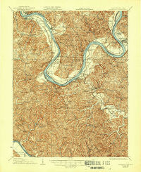
Ravenswood, West Virginia, USGS topographic map dated 1928.
Includes geographic coordinates (latitude and longitude). This topographic map is suitable for hiking, camping, and exploring, or framing it as a wall map.
Printed on-demand using high resolution imagery, on heavy weight and acid free paper, or alternatively on a variety of synthetic materials.
Topos available on paper, Waterproof, Poly, or Tyvek. Usually shipping rolled, unless combined with other folded maps in one order.
- Product Number: USGS-5415820
- Free digital map download (high-resolution, GeoPDF): Ravenswood, West Virginia (file size: 13 MB)
- Map Size: please refer to the dimensions of the GeoPDF map above
- Weight (paper map): ca. 55 grams
- Map Type: POD USGS Topographic Map
- Map Series: HTMC
- Map Verison: Historical
- Cell ID: 320816
- Scan ID: 253815
- Imprint Year: 1944
- Survey Year: 1906
- Datum: NAD
- Map Projection: Polyconic
- Map published by United States Geological Survey
- Map Language: English
- Scanner Resolution: 600 dpi
- Map Cell Name: Ravenswood
- Grid size: 15 X 15 Minute
- Date on map: 1928
- Map Scale: 1:62500
- Geographical region: West Virginia, United States
Neighboring Maps:
All neighboring USGS topo maps are available for sale online at a variety of scales.
Spatial coverage:
Topo map Ravenswood, West Virginia, covers the geographical area associated the following places:
- Ash - Condeville - Estar - Danstown - Great Bend - School House (historical) - Evans - Ravenswood - Letart - Rollins - North Ravenswood - Oldtown Flats - Chestnut - Spiller - Gunville - Ripley Landing - Evergreen Hills - Longdale - Pleasant View - Board - Hills Crossing - East Letart - Saxon - Angerona - Upper Flats - Sherman - Oakgrove (historical) - New Haven - Leon - Syracuse - Ulric - Plants - Letart Falls - Cottageville - Flatwoods - Baden - Antiquity - Providence - Mount Alto - Millwood - Dorcas - Apple Grove - Rolandus - Mount Moriah - Racine - Wood - Willow Grove (historical) - Huntsville (historical)
- Map Area ID: AREA3938.75-82-81.75
- Northwest corner Lat/Long code: USGSNW39-82
- Northeast corner Lat/Long code: USGSNE39-81.75
- Southwest corner Lat/Long code: USGSSW38.75-82
- Southeast corner Lat/Long code: USGSSE38.75-81.75
- Northern map edge Latitude: 39
- Southern map edge Latitude: 38.75
- Western map edge Longitude: -82
- Eastern map edge Longitude: -81.75


