
~ Seattle WA topo map, 1:250000 scale, 1 X 2 Degree, Historical, 1958, updated 1975
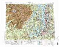
Seattle, Washington, USGS topographic map dated 1958.
Includes geographic coordinates (latitude and longitude). This topographic map is suitable for hiking, camping, and exploring, or framing it as a wall map.
Printed on-demand using high resolution imagery, on heavy weight and acid free paper, or alternatively on a variety of synthetic materials.
Topos available on paper, Waterproof, Poly, or Tyvek. Usually shipping rolled, unless combined with other folded maps in one order.
- Product Number: USGS-5411532
- Free digital map download (high-resolution, GeoPDF): Seattle, Washington (file size: 30 MB)
- Map Size: please refer to the dimensions of the GeoPDF map above
- Weight (paper map): ca. 55 grams
- Map Type: POD USGS Topographic Map
- Map Series: HTMC
- Map Verison: Historical
- Cell ID: 72248
- Scan ID: 243646
- Imprint Year: 1975
- Woodland Tint: Yes
- Aerial Photo Year: 1973
- Edit Year: 1974
- Field Check Year: 1958
- Datum: Unstated
- Map Projection: Transverse Mercator
- Map published by: Military, Other
- Map Language: English
- Scanner Resolution: 600 dpi
- Map Cell Name: Seattle
- Grid size: 1 X 2 Degree
- Date on map: 1958
- Map Scale: 1:250000
- Geographical region: Washington, United States
Neighboring Maps:
All neighboring USGS topo maps are available for sale online at a variety of scales.
Spatial coverage:
Topo map Seattle, Washington, covers the geographical area associated the following places:
- American Lake Garden Tract - Northwest Mobile Home Park - Puyallup - Norwood - Mountain View Estates Mobile Home Park - Dewatto - Hamma Hamma - Edmonds - Neilton - Waller - Oak Acres Mobile Home Park - Taylor Towne Manor Mobile Home Park - Highlands Park - Adelaide - Airport Inn Mobile Home Park - Navy Yard City - Rhododendron Park - Southgate Mobile Home Park - Zenith - University Village - Kitsap Lake - Kingsgate - Briercrest - Northeast Tacoma - Duwamish - Meridian Terrace Mobile Manor - Alpine Estates Mobile Home Park - Carlton Park - Duckabush - Golden Bell Mobile Home Park - Maple Leaf - Jamison Corner - South Park - Enchanted Firs Mobile Home Park - Silverdale Mobile Estates - Maplewood Heights - Beaver Valley - Vashon - Evansville - Wollochet - Fox Island - Suquamish - Inglewood Estates Mobile Home Park - Mountain View Villa Mobile Home Park - Moorlands - Johnson Landing - Green Lake - Ardenia Gale Mobile Home Park - Parkwood - Pantera Lago Estates Mobile Home Park - Briarcliff - Burton - May Valley Manor Mobile Home Park - Parkland Mobile Village - Port Gamble - Heritage Mobile Home Park - Lilliwaup - Sunset Farm - Marshville (historical) - The River Mobile Estates - Laurelwood Mobile Home Park - Alpine Mobile Home Park - Summer Villa Estates Mobile Home Park - Midland - Cardinal Estates Mobile Home Park - Mohrweis - Tanwax - Harborland Mobile Home Park - East Seattle - Seola Beach - Cascade - Midway - Gig Harbor - Coach Country Corral Mobile Home Park - Broadview - Eastgate - Silver Creek Meadows Mobile Home Park - Vaugans Mobile Home Park - Oskams Corner - Retsil - Lake Meridian Estates Mobile Home Park - Star Lake - Skylark Village Mobile Home Park - Skyway - Olympic View Mobile Manor - Lake Hills - Evergreen Manor Mobile Home Park - Milton - Woodway - Gregory Heights - Grant - Bonney Lake - Leisure Manor Mobile Community - Valleybrook Mobile Home Park - Ballow - Greenwood - Meridian - Madison Park - Maynard - McCleary
- Map Area ID: AREA4847-124-122
- Northwest corner Lat/Long code: USGSNW48-124
- Northeast corner Lat/Long code: USGSNE48-122
- Southwest corner Lat/Long code: USGSSW47-124
- Southeast corner Lat/Long code: USGSSE47-122
- Northern map edge Latitude: 48
- Southern map edge Latitude: 47
- Western map edge Longitude: -124
- Eastern map edge Longitude: -122


