
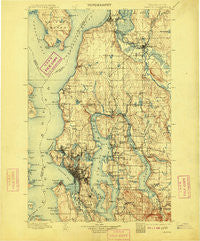
~ Seattle WA topo map, 1:125000 scale, 30 X 30 Minute, Historical, 1897, updated 1909
Seattle, Washington, USGS topographic map dated 1897.
Includes geographic coordinates (latitude and longitude). This topographic map is suitable for hiking, camping, and exploring, or framing it as a wall map.
Printed on-demand using high resolution imagery, on heavy weight and acid free paper, or alternatively on a variety of synthetic materials.
Topos available on paper, Waterproof, Poly, or Tyvek. Usually shipping rolled, unless combined with other folded maps in one order.
- Product Number: USGS-5411326
- Free digital map download (high-resolution, GeoPDF): Seattle, Washington (file size: 10 MB)
- Map Size: please refer to the dimensions of the GeoPDF map above
- Weight (paper map): ca. 55 grams
- Map Type: POD USGS Topographic Map
- Map Series: HTMC
- Map Verison: Historical
- Cell ID: 66651
- Scan ID: 243639
- Imprint Year: 1909
- Survey Year: 1895
- Datum: Unstated
- Map Projection: Unstated
- Map published by United States Geological Survey
- Map Language: English
- Scanner Resolution: 600 dpi
- Map Cell Name: Snohomish
- Grid size: 30 X 30 Minute
- Date on map: 1897
- Map Scale: 1:125000
- Geographical region: Washington, United States
Neighboring Maps:
All neighboring USGS topo maps are available for sale online at a variety of scales.
Spatial coverage:
Topo map Seattle, Washington, covers the geographical area associated the following places:
- Ballard - Fremont - Campton - Holly Hills Mobile Home Park - Martha Lake - Meridian Village Mobile Home - Machias Mobile Manor - McGilvara - Newport - Mukilteo - Yesler Terrace - Cardinal Estates Mobile Home Park - Lakeview Mobile Home Park - Fortuna - Willows - Fairway Estates Senior Mobile Home Park - Center Mobile Park - Feriton - Fobes Hill - North Creek - Arroyo Heights - Firwood Lane Mobile Home Park - Magnolia Bluff - J and L Mobile Home Park - Sunlight Beach - Westburg Mobile Park - Maxwelton - Paramount Park - Snohomish - Foy - Finn Hill - Country Carriage Estates Mobile Home Park - Queen Anne - Westridge Estates Mobile Home Park - Penny Lynn Mobile Home Park - Yarrow Point - Kingsbury West Mobile Home Park - Madison Park - Hunts Point - Pinehurst - Delridge - Avon Villa Mobile Home Park - Creekside Mobile Home Park - West Lake Sammamish - Capitol Hill - Lake Stickney - Three Rivers Mobile Home Park - Georgetown - Norwood Village - Kennard Mobile Estates - Seattle Heights Mobile Home Park - Matthews Beach - Woodruff - Kingston - Broadway - Midlakes - Pinehurst - Eastland - Loganberry Mobile Home Park - Wintermutes Corner - Factoria - Ross (historical) - Woodway - Chinook Mobile Home Park - Laurelhurst - Endolyne - Serene - Larimers Corner - Glendale - Mountlake Terrace - Hazelwood - Serene Terrace Mobile Home Park - Snyders Corner - Sand Point - University District - Clinton - Columbia - Marks Mobile Home Park - Alpine Mobile Home Park - Ridgecrest - Clyde Hill - Morningside - Carriage Club Estates Mobile Home Park - Youngs Mobile Home Park - Tamill - Martha Lake Mobile Manor - Lake Forest Park - Royal Coachman Mobile Home Park - Freeway Place Mobile Home Park - Duwamish - North College Park - Bella Mobile Home Park - Arbor Heights - Ravenna - Kenwood - Village Green Mobile Home Park - University - Medina - West Seattle - Roosevelt
- Map Area ID: AREA4847.5-122.5-122
- Northwest corner Lat/Long code: USGSNW48-122.5
- Northeast corner Lat/Long code: USGSNE48-122
- Southwest corner Lat/Long code: USGSSW47.5-122.5
- Southeast corner Lat/Long code: USGSSE47.5-122
- Northern map edge Latitude: 48
- Southern map edge Latitude: 47.5
- Western map edge Longitude: -122.5
- Eastern map edge Longitude: -122


