
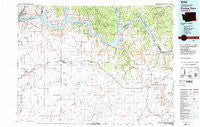
~ Coulee Dam WA topo map, 1:100000 scale, 30 X 60 Minute, Historical, 1983, updated 1983
Coulee Dam, Washington, USGS topographic map dated 1983.
Includes geographic coordinates (latitude and longitude). This topographic map is suitable for hiking, camping, and exploring, or framing it as a wall map.
Printed on-demand using high resolution imagery, on heavy weight and acid free paper, or alternatively on a variety of synthetic materials.
Topos available on paper, Waterproof, Poly, or Tyvek. Usually shipping rolled, unless combined with other folded maps in one order.
- Product Number: USGS-5410970
- Free digital map download (high-resolution, GeoPDF): Coulee Dam, Washington (file size: 26 MB)
- Map Size: please refer to the dimensions of the GeoPDF map above
- Weight (paper map): ca. 55 grams
- Map Type: POD USGS Topographic Map
- Map Series: HTMC
- Map Verison: Historical
- Cell ID: 67347
- Scan ID: 240709
- Imprint Year: 1983
- Woodland Tint: Yes
- Aerial Photo Year: 1978
- Edit Year: 1983
- Datum: NAD27
- Map Projection: Universal Transverse Mercator
- Map published by United States Geological Survey
- Map Language: English
- Scanner Resolution: 600 dpi
- Map Cell Name: Coulee Dam
- Grid size: 30 X 60 Minute
- Date on map: 1983
- Map Scale: 1:100000
- Geographical region: Washington, United States
Neighboring Maps:
All neighboring USGS topo maps are available for sale online at a variety of scales.
Spatial coverage:
Topo map Coulee Dam, Washington, covers the geographical area associated the following places:
- Mason City (historical) - Sherman - Elmer City - Mondovi - Wilbur - Lincoln - Crown Point Vista - East Heights - Davenport - Hesseltine - Miles - Rocklyn - Lone Pine - Earl - Coulee Dam - Telford - Bluestem - Omans - Creston - Fort Spokane - Bagdad Junction - Mason City - Seven Bays - Govan - Almira
- Map Area ID: AREA4847.5-119-118
- Northwest corner Lat/Long code: USGSNW48-119
- Northeast corner Lat/Long code: USGSNE48-118
- Southwest corner Lat/Long code: USGSSW47.5-119
- Southeast corner Lat/Long code: USGSSE47.5-118
- Northern map edge Latitude: 48
- Southern map edge Latitude: 47.5
- Western map edge Longitude: -119
- Eastern map edge Longitude: -118


