
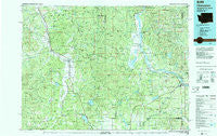
~ Chewelah WA topo map, 1:100000 scale, 30 X 60 Minute, Historical, 1984, updated 1984
Chewelah, Washington, USGS topographic map dated 1984.
Includes geographic coordinates (latitude and longitude). This topographic map is suitable for hiking, camping, and exploring, or framing it as a wall map.
Printed on-demand using high resolution imagery, on heavy weight and acid free paper, or alternatively on a variety of synthetic materials.
Topos available on paper, Waterproof, Poly, or Tyvek. Usually shipping rolled, unless combined with other folded maps in one order.
- Product Number: USGS-5410956
- Free digital map download (high-resolution, GeoPDF): Chewelah, Washington (file size: 33 MB)
- Map Size: please refer to the dimensions of the GeoPDF map above
- Weight (paper map): ca. 55 grams
- Map Type: POD USGS Topographic Map
- Map Series: HTMC
- Map Verison: Historical
- Cell ID: 67284
- Scan ID: 240476
- Imprint Year: 1984
- Woodland Tint: Yes
- Aerial Photo Year: 1977
- Edit Year: 1984
- Datum: NAD27
- Map Projection: Universal Transverse Mercator
- Map published by United States Geological Survey
- Map Language: English
- Scanner Resolution: 600 dpi
- Map Cell Name: Chewelah
- Grid size: 30 X 60 Minute
- Date on map: 1984
- Map Scale: 1:100000
- Geographical region: Washington, United States
Neighboring Maps:
All neighboring USGS topo maps are available for sale online at a variety of scales.
Spatial coverage:
Topo map Chewelah, Washington, covers the geographical area associated the following places:
- Addy - Country Villa Mobile Estates - Ridgecrest Mobile Home Park - Fairview - Camden - Tweedie - Springdale - Newport - Hartill's Ridgecrest Mobile Home Park - Kulzer - Camas - Bluecreek - Orin - Panorama Mobile Home Park - Valley - Dalkena - Gardners Mobile Home Park - Penrith - Bingville - Furport - Calispell - Loon Lake Acres Mobile Home Park - Wolfred - Carrs Corner - Oldtown - Arden - Locke - Cusick - Delkena - Grays Landing - Pocahontas Bay - Deer Valley - Cline - Steven's Street Mobile Home Park - Grays - Schmidt (historical) - Cozy Nook - Scotia - Country Hills Mobile Home Park - Jared - Waits - Lazy Acres Mobile Home Park - Diamond Lake - Grahams - Chewelah - Usk - Loon Lake - Elk
- Map Area ID: AREA48.548-118-117
- Northwest corner Lat/Long code: USGSNW48.5-118
- Northeast corner Lat/Long code: USGSNE48.5-117
- Southwest corner Lat/Long code: USGSSW48-118
- Southeast corner Lat/Long code: USGSSE48-117
- Northern map edge Latitude: 48.5
- Southern map edge Latitude: 48
- Western map edge Longitude: -118
- Eastern map edge Longitude: -117


