
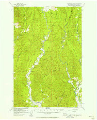
~ Wynoochee Valley WA topo map, 1:62500 scale, 15 X 15 Minute, Historical, 1955, updated 1957
Wynoochee Valley, Washington, USGS topographic map dated 1955.
Includes geographic coordinates (latitude and longitude). This topographic map is suitable for hiking, camping, and exploring, or framing it as a wall map.
Printed on-demand using high resolution imagery, on heavy weight and acid free paper, or alternatively on a variety of synthetic materials.
Topos available on paper, Waterproof, Poly, or Tyvek. Usually shipping rolled, unless combined with other folded maps in one order.
- Product Number: USGS-5410918
- Free digital map download (high-resolution, GeoPDF): Wynoochee Valley, Washington (file size: 10 MB)
- Map Size: please refer to the dimensions of the GeoPDF map above
- Weight (paper map): ca. 55 grams
- Map Type: POD USGS Topographic Map
- Map Series: HTMC
- Map Verison: Historical
- Cell ID: 64740
- Scan ID: 244798
- Imprint Year: 1957
- Woodland Tint: Yes
- Aerial Photo Year: 1953
- Field Check Year: 1955
- Datum: NAD27
- Map Projection: Polyconic
- Map published by United States Geological Survey
- Map Language: English
- Scanner Resolution: 600 dpi
- Map Cell Name: Wynoochee Valley
- Grid size: 15 X 15 Minute
- Date on map: 1955
- Map Scale: 1:62500
- Geographical region: Washington, United States
Neighboring Maps:
All neighboring USGS topo maps are available for sale online at a variety of scales.
Spatial coverage:
Topo map Wynoochee Valley, Washington, covers the geographical area associated the following places:
- Grays Harbor Fire District 2 Wynoochee Station 33 - Prices Peak - Bitter Creek - Neil Creek - Evergreen Quarry - Coal Creek - Black Creek - Carter Creek - East Fork Sylvia Creek - West Fork Satsop River - Brady Census Designated Place - East Fork Satsop River - Olympic State Wildlife Recreation Area - Anderson Creek - Smith Creek - Still Creek - Wynoochee Valley Grange - Schafer Creek - Swinging Bridge Park (historical) - Caldwell Creek - Mobray Lookout (historical) - Canyon River - Lake Sylvia State Park - Wishkah Quarry - Cougar Smith Road Bridge - City of Montesano - Studer Quarry - Wedekind Creek - Montesano Division - Helm Creek - Big Creek - West Fork Sylvia Creek - Parker Creek - Mooney Creek
- Map Area ID: AREA47.2547-123.75-123.5
- Northwest corner Lat/Long code: USGSNW47.25-123.75
- Northeast corner Lat/Long code: USGSNE47.25-123.5
- Southwest corner Lat/Long code: USGSSW47-123.75
- Southeast corner Lat/Long code: USGSSE47-123.5
- Northern map edge Latitude: 47.25
- Southern map edge Latitude: 47
- Western map edge Longitude: -123.75
- Eastern map edge Longitude: -123.5


