
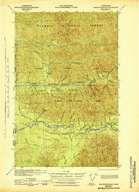
~ Spruce Mountain WA topo map, 1:62500 scale, 15 X 15 Minute, Historical, 1943
Spruce Mountain, Washington, USGS topographic map dated 1943.
Includes geographic coordinates (latitude and longitude). This topographic map is suitable for hiking, camping, and exploring, or framing it as a wall map.
Printed on-demand using high resolution imagery, on heavy weight and acid free paper, or alternatively on a variety of synthetic materials.
Topos available on paper, Waterproof, Poly, or Tyvek. Usually shipping rolled, unless combined with other folded maps in one order.
- Product Number: USGS-5410718
- Free digital map download (high-resolution, GeoPDF): Spruce Mountain, Washington (file size: 10 MB)
- Map Size: please refer to the dimensions of the GeoPDF map above
- Weight (paper map): ca. 55 grams
- Map Type: POD USGS Topographic Map
- Map Series: HTMC
- Map Verison: Historical
- Cell ID: 62886
- Scan ID: 243971
- Woodland Tint: Yes
- Datum: NAD27
- Map Projection: Polyconic
- Map published by United States Army Corps of Engineers
- Map published by United States Department of War
- Map Language: English
- Scanner Resolution: 600 dpi
- Map Cell Name: Spruce Mountain
- Grid size: 15 X 15 Minute
- Date on map: 1943
- Map Scale: 1:62500
- Geographical region: Washington, United States
Neighboring Maps:
All neighboring USGS topo maps are available for sale online at a variety of scales.
Spatial coverage:
Topo map Spruce Mountain, Washington, covers the geographical area associated the following places:
- Brush Creek - Peak Six - Brandeberry Creek - Vast Creek - Tumwata Creek - Spruce Creek - Boulevard Creek - Huelsdonk Ranch - Fraker Creek - Huelsdonk Ridge - Bogachiel-Hoh Trail - Indian Creek - Fisher Ranch - Pete Creek - Spruce Mountain - Devil Club Creek - Rugged Ridge Trail - Sitkum River - Dismal Creek - Fifteenmile Shelter - Alder Creek - Pass Trail - Hunger Mountain - Elk Creek - Kloshe Creek - Schmidt Ranch - North Fork Sitkum River - Bogachiel - Flapjack Shelter - Willoughby Creek Campground - Rugged Ridge - Elbow Creek - Shanty Creek - Huelsdonk Campground - Winfield Creek - Canyon Creek - Geodetic Hill - South Fork Hoh River - Warkum Creek - Red Creek - Minnie Peterson Campground - Clear Creek - Cultus Creek - North Fork Bogachiel River - Hyas Lookout - Lindner Creek - Dry Creek - Willoughby Creek - Spruce Creek - Lewis Ranch - Slide Creek - All-In Creek - Hades Creek - Bee Creek - Rainbow Creek - Owl Creek - Pole Creek - Sitkum Shelter - Mosquito Creek - Calawah Shelter - Sunday Creek - Bogachiel Shelter - Snell Creek - South Fork Owl Creek - Huelsdonk Bridge - Mineral Creek - Tower Creek - Lotloh Creek - Maple Creek - Kahkwa Creek - Olallie Creek
- Map Area ID: AREA4847.75-124.25-124
- Northwest corner Lat/Long code: USGSNW48-124.25
- Northeast corner Lat/Long code: USGSNE48-124
- Southwest corner Lat/Long code: USGSSW47.75-124.25
- Southeast corner Lat/Long code: USGSSE47.75-124
- Northern map edge Latitude: 48
- Southern map edge Latitude: 47.75
- Western map edge Longitude: -124.25
- Eastern map edge Longitude: -124


