
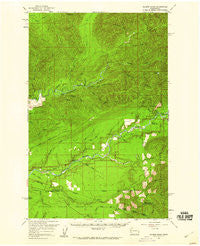
~ Salmon River WA topo map, 1:62500 scale, 15 X 15 Minute, Historical, 1956, updated 1960
Salmon River, Washington, USGS topographic map dated 1956.
Includes geographic coordinates (latitude and longitude). This topographic map is suitable for hiking, camping, and exploring, or framing it as a wall map.
Printed on-demand using high resolution imagery, on heavy weight and acid free paper, or alternatively on a variety of synthetic materials.
Topos available on paper, Waterproof, Poly, or Tyvek. Usually shipping rolled, unless combined with other folded maps in one order.
- Product Number: USGS-5410608
- Free digital map download (high-resolution, GeoPDF): Salmon River, Washington (file size: 10 MB)
- Map Size: please refer to the dimensions of the GeoPDF map above
- Weight (paper map): ca. 55 grams
- Map Type: POD USGS Topographic Map
- Map Series: HTMC
- Map Verison: Historical
- Cell ID: 62040
- Scan ID: 243570
- Imprint Year: 1960
- Woodland Tint: Yes
- Aerial Photo Year: 1952
- Field Check Year: 1956
- Datum: NAD27
- Map Projection: Polyconic
- Map published by United States Geological Survey
- Map Language: English
- Scanner Resolution: 600 dpi
- Map Cell Name: Salmon River
- Grid size: 15 X 15 Minute
- Date on map: 1956
- Map Scale: 1:62500
- Geographical region: Washington, United States
Neighboring Maps:
All neighboring USGS topo maps are available for sale online at a variety of scales.
Spatial coverage:
Topo map Salmon River, Washington, covers the geographical area associated the following places:
- Willamaud Creek - McKinnon Creek - Queets Corridor - Hibbard Creek - Manor Creek - Mount Octopus - Boulder Creek - Middle Fork Salmon River - Knorr Creek - Prairie Creek - Clearwater Honor Camp - Snahapish River - Crooks Creek - Sams Rapids - Olympic Correctional Center - West End Division - Crooks Rapids - Peterson Creek - North Fork Manor Creek - Yahoo Lake Campground - Itswoot Creek - Yahoo Lake - Sams River - Tacoma Creek - Solleks River - Stequaleho Creek - Queets Campground - Copper Mine Botton Campground - Lyman Rapids - South Fork Manor Creek - East Fork Tacoma Creek - Olympic Correctional Center Wastewater Treatment Plant - Kunamakst Creek - Matheny Creek - Miller Creek - South Fork Salmon River - North Fork Salmon River - East Fork Miller Creek - Christmas Creek - Salmon River - Bull Creek - Mud Creek - Queets Ranger Station - Rocky Rapids - Phelan Creek - Upper Clearwater Campground - Deception Creek
- Map Area ID: AREA47.7547.5-124.25-124
- Northwest corner Lat/Long code: USGSNW47.75-124.25
- Northeast corner Lat/Long code: USGSNE47.75-124
- Southwest corner Lat/Long code: USGSSW47.5-124.25
- Southeast corner Lat/Long code: USGSSE47.5-124
- Northern map edge Latitude: 47.75
- Southern map edge Latitude: 47.5
- Western map edge Longitude: -124.25
- Eastern map edge Longitude: -124


