
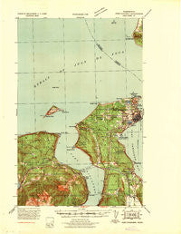
~ Port Townsend WA topo map, 1:62500 scale, 15 X 15 Minute, Historical, 1939
Port Townsend, Washington, USGS topographic map dated 1939.
Includes geographic coordinates (latitude and longitude). This topographic map is suitable for hiking, camping, and exploring, or framing it as a wall map.
Printed on-demand using high resolution imagery, on heavy weight and acid free paper, or alternatively on a variety of synthetic materials.
Topos available on paper, Waterproof, Poly, or Tyvek. Usually shipping rolled, unless combined with other folded maps in one order.
- Product Number: USGS-5410494
- Free digital map download (high-resolution, GeoPDF): Port Townsend, Washington (file size: 7 MB)
- Map Size: please refer to the dimensions of the GeoPDF map above
- Weight (paper map): ca. 55 grams
- Map Type: POD USGS Topographic Map
- Map Series: HTMC
- Map Verison: Historical
- Cell ID: 61207
- Scan ID: 243239
- Woodland Tint: Yes
- Aerial Photo Year: 1936
- Datum: NAD27
- Map Projection: Polyconic
- Advance: Yes
- Map published by United States Army Corps of Engineers
- Map Language: English
- Scanner Resolution: 600 dpi
- Map Cell Name: Port Townsend
- Grid size: 15 X 15 Minute
- Date on map: 1939
- Map Scale: 1:62500
- Geographical region: Washington, United States
Neighboring Maps:
All neighboring USGS topo maps are available for sale online at a variety of scales.
Spatial coverage:
Topo map Port Townsend, Washington, covers the geographical area associated the following places:
- Port Discovery - Hadlock Adult Village Mobile Home Park - Mountain View Mobile Home Park - Port Hadlock - One Hawkeye Mobile Home Park - Port Townsend - McGees (historical) - Tukey - Irondale - Four Corners Olympic Mobile Village - Adelma Beach - Glen Cove - Chimacum - Moores Mobile Manor - Woodmans - Hawkeye Mobile Home Park - Gardiner - B and R Mobile Home Court - Sea Breeze Mobile Home Park - Four Corners
- Map Area ID: AREA48.2548-123-122.75
- Northwest corner Lat/Long code: USGSNW48.25-123
- Northeast corner Lat/Long code: USGSNE48.25-122.75
- Southwest corner Lat/Long code: USGSSW48-123
- Southeast corner Lat/Long code: USGSSE48-122.75
- Northern map edge Latitude: 48.25
- Southern map edge Latitude: 48
- Western map edge Longitude: -123
- Eastern map edge Longitude: -122.75


