
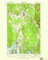
~ Marysville WA topo map, 1:62500 scale, 15 X 15 Minute, Historical, 1941, updated 1959
Marysville, Washington, USGS topographic map dated 1941.
Includes geographic coordinates (latitude and longitude). This topographic map is suitable for hiking, camping, and exploring, or framing it as a wall map.
Printed on-demand using high resolution imagery, on heavy weight and acid free paper, or alternatively on a variety of synthetic materials.
Topos available on paper, Waterproof, Poly, or Tyvek. Usually shipping rolled, unless combined with other folded maps in one order.
- Product Number: USGS-5410184
- Free digital map download (high-resolution, GeoPDF): Marysville, Washington (file size: 9 MB)
- Map Size: please refer to the dimensions of the GeoPDF map above
- Weight (paper map): ca. 55 grams
- Map Type: POD USGS Topographic Map
- Map Series: HTMC
- Map Verison: Historical
- Cell ID: 57248
- Scan ID: 242201
- Imprint Year: 1959
- Woodland Tint: Yes
- Survey Year: 1941
- Datum: NAD27
- Map Projection: Polyconic
- Map published by United States Army Corps of Engineers
- Map Language: English
- Scanner Resolution: 600 dpi
- Map Cell Name: Marysville
- Grid size: 15 X 15 Minute
- Date on map: 1941
- Map Scale: 1:62500
- Geographical region: Washington, United States
Neighboring Maps:
All neighboring USGS topo maps are available for sale online at a variety of scales.
Spatial coverage:
Topo map Marysville, Washington, covers the geographical area associated the following places:
- Stimson Crossing - Brookside Mobile Home Park - Getchell - Glenwood Mobile Estates - Pine Street Mobile Home Park - Twin Cedar Mobile Park - Airway Mobile Home Park - Snug Harbor Mobile Home Park - Smokey Point - Arlington Junction - Broadway Terrace Mobile Home Park - John Sam Lake - Smokey Point Mobile Home Park - Liberty Village Mobile Home Park - Emerald Hills Estates Mobile Home Park - Arlington - North Marysville - Edgecomb - Riverside Mobile Home Park - Lochsloy - Bryant - Everett Trailer Court - Hidden Glen Mobile Home Park - Mobile Manor - Portage Green Mobile Home Court - English - Sands 55 Plus Mobile Park - Westview Estates Mobile Home Park - Jordan - Kruse - Sobey - Sisco - Trafton - Shaker Church - Hyland - Lakewood - Arlington Heights - Delta Junction - La Tierra Mobile Home Park - Totem Park - Lake Stevens - Cedar Lane Mobile Home Park - Kellogg Village Mobile Home Park - Mobile Haven Mobile Home Park - Country Mobile Estates - Mobile Estates - Midway Gardens Mobile Park - Riverside - Crystal Tree Village Mobile Home Park - Forest Grove Mobile Home Park - Marysville - Sisco Heights - Hartford - Eagle Point Mobile Home Park - Kruse Junction
- Map Area ID: AREA48.2548-122.25-122
- Northwest corner Lat/Long code: USGSNW48.25-122.25
- Northeast corner Lat/Long code: USGSNE48.25-122
- Southwest corner Lat/Long code: USGSSW48-122.25
- Southeast corner Lat/Long code: USGSSE48-122
- Northern map edge Latitude: 48.25
- Southern map edge Latitude: 48
- Western map edge Longitude: -122.25
- Eastern map edge Longitude: -122


