
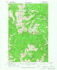
~ Chiwaukum Mts WA topo map, 1:62500 scale, 15 X 15 Minute, Historical, 1965, updated 1967
Chiwaukum Mts, Washington, USGS topographic map dated 1965.
Includes geographic coordinates (latitude and longitude). This topographic map is suitable for hiking, camping, and exploring, or framing it as a wall map.
Printed on-demand using high resolution imagery, on heavy weight and acid free paper, or alternatively on a variety of synthetic materials.
Topos available on paper, Waterproof, Poly, or Tyvek. Usually shipping rolled, unless combined with other folded maps in one order.
- Product Number: USGS-5409644
- Free digital map download (high-resolution, GeoPDF): Chiwaukum Mts, Washington (file size: 10 MB)
- Map Size: please refer to the dimensions of the GeoPDF map above
- Weight (paper map): ca. 55 grams
- Map Type: POD USGS Topographic Map
- Map Series: HTMC
- Map Verison: Historical
- Cell ID: 52538
- Scan ID: 240505
- Imprint Year: 1967
- Woodland Tint: Yes
- Aerial Photo Year: 1963
- Field Check Year: 1965
- Datum: NAD27
- Map Projection: Polyconic
- Map published by United States Geological Survey
- Map Language: English
- Scanner Resolution: 600 dpi
- Map Cell Name: Chiwarkum Mountains
- Grid size: 15 X 15 Minute
- Date on map: 1965
- Map Scale: 1:62500
- Geographical region: Washington, United States
Neighboring Maps:
All neighboring USGS topo maps are available for sale online at a variety of scales.
Spatial coverage:
Topo map Chiwaukum Mts, Washington, covers the geographical area associated the following places:
- Lake Alice - Brule Creek - Lake Flore - Wildhorse Creek - Chiwaukum Creek - Carter Lake - Chatter Creek Campground - Blackjack Ridge - Cape Horn - Lake Charles - Black Pine Campground - Lake Julius - Ladies Pass - Wenatchee National Forest - Honour Lake - Timothy Meadow - Loch Eileen - Highchair Mountain - Hoxsey Creek - Bootjack Mountain - Chiwaukum Lake - Cannon Mountain - French Creek Campground - Harding Mountain - Cradle Lake - Lake Mary - Coney Lake - Lake Margaret - Cashmere Mountain - Doctor Creek - Trout Creek - Lake Jason - Packrat Camp - Lake Brigham - Meadow Camp - Big Jim Mountain Lakes - Little Caroline Lake - Frosty Pass - Grindstone Creek - Mountaineer Creek - Lake Grace - Boggy Creek - Lake Ruth - Eightmile Creek - Frosty Creek - Chatter Guard Station - Mesa Lake - Spanish Camp Creek - Johnny Creek - Cup Lake - Mccue Ridge - Icicle Ridge - Rock Island Campground - Solomon Creek - The Badlands - Glacier Creek - Big Jim Mountain - Deadhorse Pass - Eightmile Lake Campground - Ida Creek Campground - Sixtysix Hundred Ridge - Dunn Creek - Jack Creek - Nalon Creek Game Reserve - Pablo Creek - Meadow Creek - Van Epps Mine - Little Eightmile Lake - Lake Ida - Windy Pass - Lake Caroline - Lake Donald - Grindstone Mountain - Chatter Creek - Jack Ridge - Index Creek - Upper Florence Lake - Ewing Basin - Painter Creek - Victoria Creek - Battle Canyon Creek - Earle Lake - Eightmile Campground - Upper Grace Lake - Ben Creek - Edward Peak - Jay Creek - Lake Sylvester - Eightmile Lake Outlet Dam - Fourth of July Creek - Jason Lakes - Black Pine Creek - Trout Lake Campground - South Fork Chiwaukum Creek - Bridge Creek Campground - Eightmile Lake - Ida Creek - Pioneer Creek - Eightmile Mountain - Lake Victoria
- Map Area ID: AREA47.7547.5-121-120.75
- Northwest corner Lat/Long code: USGSNW47.75-121
- Northeast corner Lat/Long code: USGSNE47.75-120.75
- Southwest corner Lat/Long code: USGSSW47.5-121
- Southeast corner Lat/Long code: USGSSE47.5-120.75
- Northern map edge Latitude: 47.75
- Southern map edge Latitude: 47.5
- Western map edge Longitude: -121
- Eastern map edge Longitude: -120.75


