
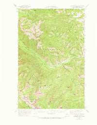
~ Buttermilk Butte WA topo map, 1:62500 scale, 15 X 15 Minute, Historical, 1969, updated 1973
Buttermilk Butte, Washington, USGS topographic map dated 1969.
Includes geographic coordinates (latitude and longitude). This topographic map is suitable for hiking, camping, and exploring, or framing it as a wall map.
Printed on-demand using high resolution imagery, on heavy weight and acid free paper, or alternatively on a variety of synthetic materials.
Topos available on paper, Waterproof, Poly, or Tyvek. Usually shipping rolled, unless combined with other folded maps in one order.
- Product Number: USGS-5409600
- Free digital map download (high-resolution, GeoPDF): Buttermilk Butte, Washington (file size: 9 MB)
- Map Size: please refer to the dimensions of the GeoPDF map above
- Weight (paper map): ca. 55 grams
- Map Type: POD USGS Topographic Map
- Map Series: HTMC
- Map Verison: Historical
- Cell ID: 51974
- Scan ID: 240289
- Imprint Year: 1973
- Woodland Tint: Yes
- Datum: NAD27
- Map Projection: Polyconic
- Map published by United States Geological Survey
- Map Language: English
- Scanner Resolution: 600 dpi
- Map Cell Name: Buttermilk Butte
- Grid size: 15 X 15 Minute
- Date on map: 1969
- Map Scale: 1:62500
- Geographical region: Washington, United States
Neighboring Maps:
All neighboring USGS topo maps are available for sale online at a variety of scales.
Spatial coverage:
Topo map Buttermilk Butte, Washington, covers the geographical area associated the following places:
- Wolf Creek Research Natural Area - War Creek - Scaffold Camp Creek - Mystery Campground - Newby Ridge - Deer Creek - Hoodoo Peak - West Fork Little Bridge Creek - Block Mountain - Little Wolf Creek - Lake Chelan-Sawtooth Wilderness - Patterson Lake Dam - Poplar Flats - Graff Creek - Buttermilk Butte - Oval Peak - Spirit Mountain - Coal Creek - Dry Creek - Shady Nook Basin - Fish Creek Pass - Newby Creek - Little Slate Creek - Reynolds Creek - Battle Mountain - Cabin Creek - Vetch Creek - Midnight Mountain - Black Pine Lake - Gray Peak - Hubbard Creek - Yoyo Creek - Courtney Peak - Cow Creek - Scaffold Peak - Horse Gulch - Oval Lakes - Whistling Creek - Tuckaway Lake - Spring Creek - Sheep Creek - West Oval Lake - Buttermilk Creek - Burnt Saw Creek - Snowshoe Ridge - East Oval Lake - South Fork Wolf Creek - Lime Creek - Buttermilk Ridge - Abernathy Ridge - North Fork Wolf Creek - Little Bridge Creek - Little Slate Lake - Spirit Peak - Cook Creek - Star Lake - Oval Creek - Silver Lake - West Fork Buttermilk Creek - Eagle Creek - Myer Creek - Gardner Meadows - Star Peak - Horseshoe Basin - Milton Mountain - War Creek Campground - East Fork Buttermilk Creek - Three A M Mountain - Eagle Pass - Poplar Flat Campground - Mission Peak - Thompson Ridge - Buttermilk Meadow - Horse Gulch Spring - Virginian Ridge - South Fork War Creek - Canyon Creek Ridge - Black Pine Creek - Gobblers Knob - Duffy Lake - Scaffold Ridge - Slate Lake - Duckbill Mountain - Blackpine Lake Campground - Valentine Creek - Williams Creek - Middle Oval Lake - Canyon Creek
- Map Area ID: AREA48.548.25-120.5-120.25
- Northwest corner Lat/Long code: USGSNW48.5-120.5
- Northeast corner Lat/Long code: USGSNE48.5-120.25
- Southwest corner Lat/Long code: USGSSW48.25-120.5
- Southeast corner Lat/Long code: USGSSE48.25-120.25
- Northern map edge Latitude: 48.5
- Southern map edge Latitude: 48.25
- Western map edge Longitude: -120.5
- Eastern map edge Longitude: -120.25


