
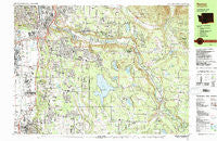
~ Renton WA topo map, 1:25000 scale, 7.5 X 15 Minute, Historical, 1983, updated 1983
Renton, Washington, USGS topographic map dated 1983.
Includes geographic coordinates (latitude and longitude). This topographic map is suitable for hiking, camping, and exploring, or framing it as a wall map.
Printed on-demand using high resolution imagery, on heavy weight and acid free paper, or alternatively on a variety of synthetic materials.
Topos available on paper, Waterproof, Poly, or Tyvek. Usually shipping rolled, unless combined with other folded maps in one order.
- Product Number: USGS-5409444
- Free digital map download (high-resolution, GeoPDF): Renton, Washington (file size: 32 MB)
- Map Size: please refer to the dimensions of the GeoPDF map above
- Weight (paper map): ca. 55 grams
- Map Type: POD USGS Topographic Map
- Map Series: HTMC
- Map Verison: Historical
- Cell ID: 75443
- Scan ID: 243423
- Imprint Year: 1983
- Woodland Tint: Yes
- Aerial Photo Year: 1977
- Edit Year: 1983
- Field Check Year: 1979
- Datum: NAD27
- Map Projection: Universal Transverse Mercator
- Map published by United States Geological Survey
- Map Language: English
- Scanner Resolution: 600 dpi
- Map Cell Name: Renton
- Grid size: 7.5 X 15 Minute
- Date on map: 1983
- Map Scale: 1:25000
- Geographical region: Washington, United States
Neighboring Maps:
All neighboring USGS topo maps are available for sale online at a variety of scales.
Spatial coverage:
Topo map Renton, Washington, covers the geographical area associated the following places:
- Tiger Mountain Mobile Home Park - High Valley - Wilderness Village - Dorre Don - East Hill - Arcadia - Valley View Mobile Home Park - Cedar Grove Mobile Home Park - Orchard Grove - May Valley Manor Mobile Home Park - Wonderland Mobile Homes - Maplewood - Highlands Park - Maplewood Heights - Lake Desire - Wilderness - Mirrormount Estates - Fairwood - Cascade - Cedar Mountain - Emerald Crest Mobile Home Park - Canyon View Mobile Home Park - Maple Valley - Atkinson - Benson Hill - Noble - Willo Vista Mobile Estates - Pantera Lago Estates Mobile Home Park - East Renton Highlands - Maple Hills - Benson Village Mobile Home Park - Leisure Estates Mobile Home Park - Vantage Glen Mobile Home Park - Paradise Mobile Home Park - Hi - Land Mobile Manor - Meridian Heights - Maple Valley Heights - Elliott - Kent - Renton - O'Brien - Tahoma - Cedar Grove - East Hill Estates Mobile Home Park - Riverbend Mobile Home Park - Orillia - Sunnydale Mobile Home Park
- Map Area ID: AREA47.547.375-122.25-122
- Northwest corner Lat/Long code: USGSNW47.5-122.25
- Northeast corner Lat/Long code: USGSNE47.5-122
- Southwest corner Lat/Long code: USGSSW47.375-122.25
- Southeast corner Lat/Long code: USGSSE47.375-122
- Northern map edge Latitude: 47.5
- Southern map edge Latitude: 47.375
- Western map edge Longitude: -122.25
- Eastern map edge Longitude: -122


