
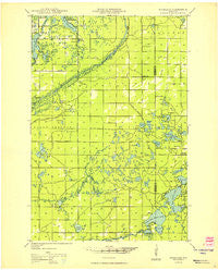
~ Highland WI topo map, 1:48000 scale, 15 X 15 Minute, Historical, 1949
Highland, Wisconsin, USGS topographic map dated 1949.
Includes geographic coordinates (latitude and longitude). This topographic map is suitable for hiking, camping, and exploring, or framing it as a wall map.
Printed on-demand using high resolution imagery, on heavy weight and acid free paper, or alternatively on a variety of synthetic materials.
Topos available on paper, Waterproof, Poly, or Tyvek. Usually shipping rolled, unless combined with other folded maps in one order.
- Product Number: USGS-5308048
- Free digital map download (high-resolution, GeoPDF): Highland, Wisconsin (file size: 8 MB)
- Map Size: please refer to the dimensions of the GeoPDF map above
- Weight (paper map): ca. 55 grams
- Map Type: POD USGS Topographic Map
- Map Series: HTMC
- Map Verison: Historical
- Cell ID: 53842
- Scan ID: 700243
- Woodland Tint: Yes
- Aerial Photo Year: 1945
- Field Check Year: 1945
- Datum: NAD27
- Map Projection: Polyconic
- Planimetric: Yes
- Map published by United States Geological Survey
- Map Language: English
- Scanner Resolution: 508 dpi
- Map Cell Name: Ellison Lake
- Grid size: 15 X 15 Minute
- Date on map: 1949
- Map Scale: 1:48000
- Geographical region: Wisconsin, United States
Neighboring Maps:
All neighboring USGS topo maps are available for sale online at a variety of scales.
Spatial coverage:
Topo map Highland, Wisconsin, covers the geographical area associated the following places:
- Cedar Island Ponds - Lund Lake - Lucius Lake - Mud Creek - Horseshoe Lake - Simms Lake - Twin Lakes - Rock Lake - Boot Lake - Hay Lake - Lake Minnesuing - Plate Lake - Highland Volunteer Fire Department - WHSA-FM (Brule) - Turtle Lake - Deer Lake - Little Simms Lake - Highland Memorial Cemetery - Cedar Island Estate - Cranberry Lake - Stones Bridge - Hopkins Lake - Rainbow Bend - Big Lake - Lower Eau Claire Lake 55 - Spring Angel Creek - Pickerel Lake - Flat Lake - East Fork Bois Brule River - Middle Eau Claire Lake 2WP366 Dam - Sand Lake - Highland Lookout Tower - Highland Townhall - Minnesuing Creek - Sunfish Lake - McDougal Springs - Smith Lake - Sucker Lake - Whiteside Lake - Island Lake - High Life Lake - Ellison Lake - Minnesuing Airport - Metzger Lake - Shoberg Lake - Big Twin Rapids - Paradise Lake - Jerseth Creek - Stones Bridge Landing - George Lake - West Fork Bois Brule River - Bass Lake - Muck Lake - Beauregard Lake - Black Fox Lake - Brule River State Forest - Anderson Lake - Mooney Dam County Park - Wilson Creek - Ole Lake - Breakfast Lake - Wildcat Rapids - Rush Lake - Sand Bar Lake - Lucius Lake - Gander Lake - Lake Minnesuing County Park - Jack Pine Lake - Upper Ox Lake - Barnes Volunteer Fire Department - Mimi Lake - Idlewild Lake - Middle Eau Claire Lake - Town of Highland - Swenson Lake - Beaupre Springs - Brule Lookout Tower - Murray Lake - Mud Lake - Loon Lake - Moreland Lake - Cedar Island Airport - Barnes Cemetery - Mays Rips Rapids - Mirror Lake - Flamang Lake - The Falls Rapids - Little Twin Rapids - Tomahawk Lake - Bony Lake - Blue Lake - Cheney Lake - Camp Bovey - Cream Lake - Deer Print Lake - Middle Eau Claire Lake 57 - Whisky Lake - Priest Lake - Blue Springs - Brule Rush Lake State Natural Area
- Map Area ID: AREA46.546.25-91.75-91.5
- Northwest corner Lat/Long code: USGSNW46.5-91.75
- Northeast corner Lat/Long code: USGSNE46.5-91.5
- Southwest corner Lat/Long code: USGSSW46.25-91.75
- Southeast corner Lat/Long code: USGSSE46.25-91.5
- Northern map edge Latitude: 46.5
- Southern map edge Latitude: 46.25
- Western map edge Longitude: -91.75
- Eastern map edge Longitude: -91.5


