
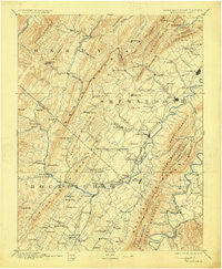
~ Woodstock VA topo map, 1:125000 scale, 30 X 30 Minute, Historical, 1892, updated 1912
Woodstock, Virginia, USGS topographic map dated 1892.
Includes geographic coordinates (latitude and longitude). This topographic map is suitable for hiking, camping, and exploring, or framing it as a wall map.
Printed on-demand using high resolution imagery, on heavy weight and acid free paper, or alternatively on a variety of synthetic materials.
Topos available on paper, Waterproof, Poly, or Tyvek. Usually shipping rolled, unless combined with other folded maps in one order.
- Product Number: USGS-5304166
- Free digital map download (high-resolution, GeoPDF): Woodstock, Virginia (file size: 7 MB)
- Map Size: please refer to the dimensions of the GeoPDF map above
- Weight (paper map): ca. 55 grams
- Map Type: POD USGS Topographic Map
- Map Series: HTMC
- Map Verison: Historical
- Cell ID: 66973
- Scan ID: 189216
- Imprint Year: 1912
- Survey Year: 1886
- Datum: Unstated
- Map Projection: Unstated
- Map published by United States Geological Survey
- Map Language: English
- Scanner Resolution: 600 dpi
- Map Cell Name: Woodstock
- Grid size: 30 X 30 Minute
- Date on map: 1892
- Map Scale: 1:125000
- Geographical region: Virginia, United States
Neighboring Maps:
All neighboring USGS topo maps are available for sale online at a variety of scales.
Spatial coverage:
Topo map Woodstock, Virginia, covers the geographical area associated the following places:
- Basore - Tenth Legion - Mathias - Zenda - Edom - Wakemans Grove - Harmony - Hudson Crossroads - Van Buren Furnace - Whitehouse Landing - Rinkerton - Stultz Mill - Honeyville - Athlone - Singers Glen - Arkton - Forestville - Mauzy - Perry - Meems - Alma - Alonzaville - Readus - Battle Creek - South Jackson - Red Banks (historical) - Columbia Furnace - Hightown - Williamsville - Shavertown - Salem - New Market - Hawkinstown - Lacey Spring - Newport - Edinburg - Saint Luke - Linville - Oakwood - Egypt Bend Estates - Ingham - Macanie - Basye - Getz Corner - Lost City - Bowmans Crossing - Grove Hill - Leaksville - Sparkling Springs - Stanley - White House - Daphna - Calvary - Mount Airy - Catherine Furnace - Green Mount - Bergton - Mount Jackson - Alpine - Fulks Run - Hamburg - Locust Grove - Quicksburg - Kern Springs - Rockland - Hamburg - Plains Mill - Jerome - Honeyville - Woodstock - Genoa - Willow Grove - Mechanicsville - Shenandoah Forest - Timberville - Orkney Springs - Intersections - Mount Clifton - Shenandoah Caverns - Conicville - Hepners - Tunis - Yankeetown - Palos - Turleytown - Broadway - Cherry Grove - Coffmantown - Georgetown - Mayland
- Map Area ID: AREA3938.5-79-78.5
- Northwest corner Lat/Long code: USGSNW39-79
- Northeast corner Lat/Long code: USGSNE39-78.5
- Southwest corner Lat/Long code: USGSSW38.5-79
- Southeast corner Lat/Long code: USGSSE38.5-78.5
- Northern map edge Latitude: 39
- Southern map edge Latitude: 38.5
- Western map edge Longitude: -79
- Eastern map edge Longitude: -78.5


