
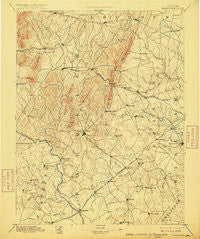
~ Warrenton VA topo map, 1:125000 scale, 30 X 30 Minute, Historical, 1894, updated 1915
Warrenton, Virginia, USGS topographic map dated 1894.
Includes geographic coordinates (latitude and longitude). This topographic map is suitable for hiking, camping, and exploring, or framing it as a wall map.
Printed on-demand using high resolution imagery, on heavy weight and acid free paper, or alternatively on a variety of synthetic materials.
Topos available on paper, Waterproof, Poly, or Tyvek. Usually shipping rolled, unless combined with other folded maps in one order.
- Product Number: USGS-5304160
- Free digital map download (high-resolution, GeoPDF): Warrenton, Virginia (file size: 7 MB)
- Map Size: please refer to the dimensions of the GeoPDF map above
- Weight (paper map): ca. 55 grams
- Map Type: POD USGS Topographic Map
- Map Series: HTMC
- Map Verison: Historical
- Cell ID: 66776
- Scan ID: 189208
- Imprint Year: 1915
- Survey Year: 1887
- Datum: Unstated
- Map Projection: Unstated
- Map published by United States Geological Survey
- Map Language: English
- Scanner Resolution: 600 dpi
- Map Cell Name: Thorofare Gap
- Grid size: 30 X 30 Minute
- Date on map: 1894
- Map Scale: 1:125000
- Geographical region: Virginia, United States
Neighboring Maps:
All neighboring USGS topo maps are available for sale online at a variety of scales.
Spatial coverage:
Topo map Warrenton, Virginia, covers the geographical area associated the following places:
- Little Georgetown - Haymarket - Cromwell - Rolling Hills - Woodlawn Farms - Levy - Royville - Waterfall - Hutchinson - Waterloo - Conklin - Stewartown - Sudley Springs - Warrenton - Mill Creek Estates - Brambleton - Old Field Estates - Doddstown - Lenah - Rock Hill - Forest Hills Estates - Turkey Run - Watson - Sowego - Vernon Mills - Marsh Run Mobile Home Park - Knollwood Estates - Crestwood Village - Gilberts Corner - Oakshade - Swansen - Waterfall Village - Cedar Knolls - Bull Run Mountain Estates - New Hope Forest - Belvoir - Zulla - Bannerwood - Fletcherville - Carlyle Station - Fayettesville - Country Scene - Colonial Acres - Linton Hall - Oak Tree Corner - Hurleyville - Tacketts Mill - Kerfoot - Bataan Village - Edwardsville - Balls Mill - Burke Meadows - Weimertown - Hopewell - Rock Hill Estates - Cliff Mills - Landmark - Liberty - Hickory Grove - Alanthus - Palmers Crossroads - Rixeyville - Countryside Estates - Brandy Station - Long Level Estates - Marshall - Bleak - Broken Hill - Erinbrook - New Market - Mountainview - Bull Run - Morgansburg - Shiloh - Delaplane - Conde - Alwington - Aquia Creek Estates - Jeffersonton - King Richard Estates - Piedmont Heights - Westgate - Bowmantown - Jacksontown - Kennard Ridge - Catlett - Zouave Hills - German - Frogtown - Bushy Acres - Aldie - Dudie - Blackwell Town - Wellington - Stafford Station - Oxfordshire - Upperville - Greenville - Olde South Estates - Lawnvale Estates
- Map Area ID: AREA3938.5-78-77.5
- Northwest corner Lat/Long code: USGSNW39-78
- Northeast corner Lat/Long code: USGSNE39-77.5
- Southwest corner Lat/Long code: USGSSW38.5-78
- Southeast corner Lat/Long code: USGSSE38.5-77.5
- Northern map edge Latitude: 39
- Southern map edge Latitude: 38.5
- Western map edge Longitude: -78
- Eastern map edge Longitude: -77.5


