
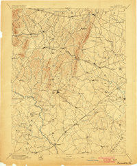
~ Warrenton VA topo map, 1:125000 scale, 30 X 30 Minute, Historical, 1894, updated 1900
Warrenton, Virginia, USGS topographic map dated 1894.
Includes geographic coordinates (latitude and longitude). This topographic map is suitable for hiking, camping, and exploring, or framing it as a wall map.
Printed on-demand using high resolution imagery, on heavy weight and acid free paper, or alternatively on a variety of synthetic materials.
Topos available on paper, Waterproof, Poly, or Tyvek. Usually shipping rolled, unless combined with other folded maps in one order.
- Product Number: USGS-5304154
- Free digital map download (high-resolution, GeoPDF): Warrenton, Virginia (file size: 8 MB)
- Map Size: please refer to the dimensions of the GeoPDF map above
- Weight (paper map): ca. 55 grams
- Map Type: POD USGS Topographic Map
- Map Series: HTMC
- Map Verison: Historical
- Cell ID: 66776
- Scan ID: 189204
- Imprint Year: 1900
- Survey Year: 1887
- Datum: Unstated
- Map Projection: Unstated
- Map published by United States Geological Survey
- Map Language: English
- Scanner Resolution: 600 dpi
- Map Cell Name: Thorofare Gap
- Grid size: 30 X 30 Minute
- Date on map: 1894
- Map Scale: 1:125000
- Geographical region: Virginia, United States
Neighboring Maps:
All neighboring USGS topo maps are available for sale online at a variety of scales.
Spatial coverage:
Topo map Warrenton, Virginia, covers the geographical area associated the following places:
- Orlean - Atoka - Elkwood - Brambleton - Bowmantown - Elk Run - Lakeview Estates - Haymarket - Morgantown - Little Georgetown - Morgansburg - The Sage - Countryside Estates - Jacksontown - Sunny Bank (historical) - Fletcherville - Lakota - Cromwell - Lenah - Old Field Estates - Halfway - Greenwich - Germantown - Aden - Doddstown - Knollwood Estates - Bannerwood - Oak Tree Corner - Churchill - Covingtons Corner - Rocky Run - Yocum - Bull Run Mountain Estates - Zulla - Eustacestown - Crescent - Rock Hill Estates - Carlyle Station - Hickory Grove - Breezy Knolls Estates - Vernon Mills - Walnut Ridge - Rixeyville - Hopewell - Morrisville - Catharpin Farms Estates - Sudley Springs - Mountain View Estates - Butler - Stewartown - Rock Hill - Meetze - Iron Gate - Rectortown - Brookes Corner - Bull Run - Beverley Mill - New Market - Lousetown - Hutchinson - Nokesville - Broken Hill - Clarks Corner - Palmers Crossroads - Colvin Farms - Hillwood Park Mobile Home Park - Crestwood Village - Saint Stephens - Skinkertown - Marshall - Kings Crossroads - Mountainview - Stoke - Levy - Tara Wood - Brent Town - Aquia Creek Estates - Midland - Westgate - Bleak - Bushy Acres - Kennard Ridge - Burns Crossroads - New Hope Forest - Ashton Glen - Waterfall Village - Airlie - Daniels Mill - Jeffersonton - Bataan Village - Wellington - Gypsum Hill Estates - Perrowville - Auburn - Millbrook - Foster Fork - Rock Hill Manors - Fayettesville - Lakeview - Forest Hills Estates
- Map Area ID: AREA3938.5-78-77.5
- Northwest corner Lat/Long code: USGSNW39-78
- Northeast corner Lat/Long code: USGSNE39-77.5
- Southwest corner Lat/Long code: USGSSW38.5-78
- Southeast corner Lat/Long code: USGSSE38.5-77.5
- Northern map edge Latitude: 39
- Southern map edge Latitude: 38.5
- Western map edge Longitude: -78
- Eastern map edge Longitude: -77.5


