
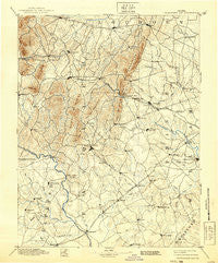
~ Thorofare Gap VA topo map, 1:125000 scale, 30 X 30 Minute, Historical, 1894, updated 1939
Thorofare Gap, Virginia, USGS topographic map dated 1894.
Includes geographic coordinates (latitude and longitude). This topographic map is suitable for hiking, camping, and exploring, or framing it as a wall map.
Printed on-demand using high resolution imagery, on heavy weight and acid free paper, or alternatively on a variety of synthetic materials.
Topos available on paper, Waterproof, Poly, or Tyvek. Usually shipping rolled, unless combined with other folded maps in one order.
- Product Number: USGS-5304148
- Free digital map download (high-resolution, GeoPDF): Thorofare Gap, Virginia (file size: 7 MB)
- Map Size: please refer to the dimensions of the GeoPDF map above
- Weight (paper map): ca. 55 grams
- Map Type: POD USGS Topographic Map
- Map Series: HTMC
- Map Verison: Historical
- Cell ID: 66776
- Scan ID: 189200
- Imprint Year: 1939
- Survey Year: 1887
- Datum: Unstated
- Map Projection: Polyconic
- Map published by United States Geological Survey
- Map Language: English
- Scanner Resolution: 600 dpi
- Map Cell Name: Thorofare Gap
- Grid size: 30 X 30 Minute
- Date on map: 1894
- Map Scale: 1:125000
- Geographical region: Virginia, United States
Neighboring Maps:
All neighboring USGS topo maps are available for sale online at a variety of scales.
Spatial coverage:
Topo map Thorofare Gap, Virginia, covers the geographical area associated the following places:
- Lakota - King Richard Estates - Oakshade - Clarks Corner - Scuffleburg - Landmark - The Sage - Sudley Mountain Estates - Upperville - Bethel - Meadowville - Yocum - Bealeton - Woodlawn Farms - Hurleyville - Dover - Millbrook - Linton Hall - Conklin - Litchfield - German - Lousetown - Knollwood Estates - Rock Hill Manors - Marshall - Somerville - Brambleton - Halfway - Rixlew - Hickory Grove Acres - Cedar Knolls - Aldie - Erinbrook - Lois - Lakeland - Fayettesville - Bull Run Mountain Estates - Ashville - Warrenton - Doddstown - Colvin Farms - Remington - Broken Hill - Alwington - Mill Creek Estates - Amissville - Hillwood Park Mobile Home Park - Broad Run - Mountainview - Rixeyville - Germantown - Old Conde - Bushy Acres - Rock Hill Estates - Vernon Mills - Beverley Mill - Bull Run - Buckland - Carolandville - Morrisville - Carlyle Station - Middleburg - Deerfield Estates - Springfield - Stafford Station - Belvoir - Greenville - Kennard Ridge - Bataan Village - Bleak - Sunny Bank (historical) - Oak Tree Corner - Walnut Ridge - Gainesville - New Baltimore - Burke Meadows - Piedmont Heights - Botha - Saint Stephens - Ridgelea - Rectortown - Zulla - Hume - Twin Oaks - Butler - Clover Hill - Boxwood Farms - Greenwich - Hutchinson - Kings Crossroads - Auburn - Brent Turf Acres - Covingtons Corner - The Plains - Oxfordshire - Groveton - Kerfoot - Brookes Corner - Catharpin Farms Estates - Marsh Run Mobile Home Park
- Map Area ID: AREA3938.5-78-77.5
- Northwest corner Lat/Long code: USGSNW39-78
- Northeast corner Lat/Long code: USGSNE39-77.5
- Southwest corner Lat/Long code: USGSSW38.5-78
- Southeast corner Lat/Long code: USGSSE38.5-77.5
- Northern map edge Latitude: 39
- Southern map edge Latitude: 38.5
- Western map edge Longitude: -78
- Eastern map edge Longitude: -77.5


