
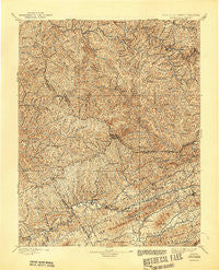
~ Tazewell VA topo map, 1:125000 scale, 30 X 30 Minute, Historical, 1897, updated 1944
Tazewell, Virginia, USGS topographic map dated 1897.
Includes geographic coordinates (latitude and longitude). This topographic map is suitable for hiking, camping, and exploring, or framing it as a wall map.
Printed on-demand using high resolution imagery, on heavy weight and acid free paper, or alternatively on a variety of synthetic materials.
Topos available on paper, Waterproof, Poly, or Tyvek. Usually shipping rolled, unless combined with other folded maps in one order.
- Product Number: USGS-5304142
- Free digital map download (high-resolution, GeoPDF): Tazewell, Virginia (file size: 12 MB)
- Map Size: please refer to the dimensions of the GeoPDF map above
- Weight (paper map): ca. 55 grams
- Map Type: POD USGS Topographic Map
- Map Series: HTMC
- Map Verison: Historical
- Cell ID: 66756
- Scan ID: 189196
- Imprint Year: 1944
- Survey Year: 1893
- Datum: Unstated
- Map Projection: Polyconic
- Map published by United States Geological Survey
- Map Language: English
- Scanner Resolution: 600 dpi
- Map Cell Name: Tazewell
- Grid size: 30 X 30 Minute
- Date on map: 1897
- Map Scale: 1:125000
- Geographical region: Virginia, United States
Neighboring Maps:
All neighboring USGS topo maps are available for sale online at a variety of scales.
Spatial coverage:
Topo map Tazewell, Virginia, covers the geographical area associated the following places:
- Matney - Hemphill - Union City - Beartown - Berwind - Amonate - Marine - Swords Creek - Big Sandy - Horsepen Cove - Newhall - Johnstown - Harman - Elbert - Doran - Coaldan - North Tazewell - Maiden Spring - Dan - Clell - Hensley - Pucketts Store - Big Four - Ream - Stony Ridge - Alpheus - Dye - Raysal - Van Dyke - English - Wilmore - Bishop - Rift - Six - Iaeger - Maitland - Sayersville - Whites Store - Mouth of Laurel - Coalwood - Benbow - Jacobs Fork - Height - Faraday - Putnam - Apple Grove - Criggers - West Raven - Nacols - Green Place - Antler - Peapatch - Joe Whites - Mount Gate - Davy - Carlos - Lake Park - Rockridge - Dalton Addition - Jolo - Peapatch - Asberrys - Roderfield - Gary - Glen Burke - Marvin - Hix (historical) - Tarkiln - Gillespie - Venus - Fork Ridge - Camp Tazewell - Lynn Spring - Bradshaw - Afredton - Garden - Erin - Clear Fork Junction - Indian - Steeleburg - Avondale - Slate - Dwight - River Jack - Wittens Fort - Hale Creek - Vallscreek - Birmingham - Jewell Ridge - Marytown - Mohegan - Patterson - Wolford - Twin Branch - Hull - Yukon - Russell - Shraders - Kimball - Maxwell
- Map Area ID: AREA37.537-82-81.5
- Northwest corner Lat/Long code: USGSNW37.5-82
- Northeast corner Lat/Long code: USGSNE37.5-81.5
- Southwest corner Lat/Long code: USGSSW37-82
- Southeast corner Lat/Long code: USGSSE37-81.5
- Northern map edge Latitude: 37.5
- Southern map edge Latitude: 37
- Western map edge Longitude: -82
- Eastern map edge Longitude: -81.5


