
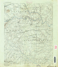
~ Spottsylvania VA topo map, 1:125000 scale, 30 X 30 Minute, Historical, 1892
Spottsylvania, Virginia, USGS topographic map dated 1892.
Includes geographic coordinates (latitude and longitude). This topographic map is suitable for hiking, camping, and exploring, or framing it as a wall map.
Printed on-demand using high resolution imagery, on heavy weight and acid free paper, or alternatively on a variety of synthetic materials.
Topos available on paper, Waterproof, Poly, or Tyvek. Usually shipping rolled, unless combined with other folded maps in one order.
- Product Number: USGS-5304106
- Free digital map download (high-resolution, GeoPDF): Spottsylvania, Virginia (file size: 6 MB)
- Map Size: please refer to the dimensions of the GeoPDF map above
- Weight (paper map): ca. 55 grams
- Map Type: POD USGS Topographic Map
- Map Series: HTMC
- Map Verison: Historical
- Cell ID: 66673
- Scan ID: 189168
- Survey Year: 1887
- Datum: Unstated
- Map Projection: Unstated
- Map published by United States Geological Survey
- Map Language: English
- Scanner Resolution: 600 dpi
- Map Cell Name: Spotsylvania
- Grid size: 30 X 30 Minute
- Date on map: 1892
- Map Scale: 1:125000
- Geographical region: Virginia, United States
Neighboring Maps:
All neighboring USGS topo maps are available for sale online at a variety of scales.
Spatial coverage:
Topo map Spottsylvania, Virginia, covers the geographical area associated the following places:
- Davis Corner - Diamond Park - Walden Ten - Rappahannock Ridge Estates - Berea Plantation - Hartwood Meadows - Lakeland Forest - Brockroad - Gold Dale - Holly Acres - Chapalita - Kirk O'Cliff - Levy - High Point - Hampshire Forest - Nancy Wrights Corner - Verdiersville - Chesterfield - Holly Corners - Nora Park - Spotsylvania Courthouse - Cropp Road Estates - Heflin - Queens Guard - Cookstown - Rivergate - Roseville Plantation - Old Banks - Logan - Walnut Grove - Porters - Mineral - Davis Corner - Georgetown West - Dan - Chesterwood - Monrovia - Lignum - Jones - Penneys Crossroad - Keatwood - Centreville - Belle Parc - Carrera Estates - Goldvein - Tatum - Indian Town - Brandy Hills - Holly Corner - Wallaces Corner - Mine Run - Meadows of Culpeper - Country Wood Estates - Mansfield Manor - Margo - Prince Dominion - Hazel Grove - Sumerduck - Wilderness - Concord - White Owl Landing - Quiet Woods Estate - Lanes Corner - Rosedale - Glendie - Unionville - Paytes - Plum Tree - Pine View - Mount Holly - Tacketts Farm - Spotsylvania - Sherwood Forest - Meadows Park - Red Hill - Stony Hill Estates - Scenic Ridge - Valhalla - Granite Springs - Ryland Corner - Alsop - Hams Ford - Monroe Farm - Batna - Wares Crossroads - Stanards Mill - Marsh Run Estates - Bledsoe Corner - Snell - Long Branch - Mount Pleasant - Peach Lawn - Milburn Estates - Windsor Forest - Cardinal Forest - The Cascades - Richardsville - Hartwood - Hartwood Village - Cypress Estates
- Map Area ID: AREA38.538-78-77.5
- Northwest corner Lat/Long code: USGSNW38.5-78
- Northeast corner Lat/Long code: USGSNE38.5-77.5
- Southwest corner Lat/Long code: USGSSW38-78
- Southeast corner Lat/Long code: USGSSE38-77.5
- Northern map edge Latitude: 38.5
- Southern map edge Latitude: 38
- Western map edge Longitude: -78
- Eastern map edge Longitude: -77.5


