
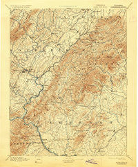
~ Buena Vista VA topo map, 1:125000 scale, 30 X 30 Minute, Historical, 1894, updated 1929
Buena Vista, Virginia, USGS topographic map dated 1894.
Includes geographic coordinates (latitude and longitude). This topographic map is suitable for hiking, camping, and exploring, or framing it as a wall map.
Printed on-demand using high resolution imagery, on heavy weight and acid free paper, or alternatively on a variety of synthetic materials.
Topos available on paper, Waterproof, Poly, or Tyvek. Usually shipping rolled, unless combined with other folded maps in one order.
- Product Number: USGS-5303786
- Free digital map download (high-resolution, GeoPDF): Buena Vista, Virginia (file size: 9 MB)
- Map Size: please refer to the dimensions of the GeoPDF map above
- Weight (paper map): ca. 55 grams
- Map Type: POD USGS Topographic Map
- Map Series: HTMC
- Map Verison: Historical
- Cell ID: 65073
- Scan ID: 188888
- Imprint Year: 1929
- Survey Year: 1888
- Datum: Unstated
- Map Projection: Polyconic
- Map published by United States Geological Survey
- Map Language: English
- Scanner Resolution: 600 dpi
- Map Cell Name: Buena Vista
- Grid size: 30 X 30 Minute
- Date on map: 1894
- Map Scale: 1:125000
- Geographical region: Virginia, United States
Neighboring Maps:
All neighboring USGS topo maps are available for sale online at a variety of scales.
Spatial coverage:
Topo map Buena Vista, Virginia, covers the geographical area associated the following places:
- Wades Mill - Piney River - Fredericksburg - Glasgow - Zack - Steeles Tavern - Goshen - Amherst - Elon - Zollman (historical) - Naola - Big Island - Faulconerville - Beverlytown - Pearch - Mechanicsville - Monroe - Stewardsburg - Coleman Falls - Coolwell - Donaldsburg - Brownsburg - Snowden - Bustleburg - Spottswood - Wilkie (historical) - Sardis - Forks of Buffalo - Midvale - Oronoco - Love - Montebello - Gidsville - Cornwall - East Lexington - Jonestown - McClung Mill - Mudtown - Waugh - Fancy Hill - Massies Mill - Tyro - Mountain View - Vesuvius - Timber Ridge - Pedlar Mills - Wilson Springs - South River - Marlbrook - Angelo - Alhambra - Five Forks - Browntown - Buena Vista - Powells Store - Monitor - Union Hill - Woodson - Balcony Falls - Enderly Heights - Crossroads Store - Sweet Briar Station - Lofton - Agricola - West Lexington - Stony Run - Nash - Mountain View - Allwood - Pera - Cedar Grove - Alto - Fairfield - Willow - White Rock - Buffalo Bend - Lowesville - Lexington - Irish Creek - Cold Spring - Davis - Shady Lane - Sandidges - Kerrs Creek - McNutt (historical) - Racy Acres - Pedlar - Pleasant View - Blacksburg - Newtown - Major - Buffalo Forge - Clifford - Buffalo Hill - Greenlee - Salt Creek - Raphine - Riverside - Decatur
- Map Area ID: AREA3837.5-79.5-79
- Northwest corner Lat/Long code: USGSNW38-79.5
- Northeast corner Lat/Long code: USGSNE38-79
- Southwest corner Lat/Long code: USGSSW37.5-79.5
- Southeast corner Lat/Long code: USGSSE37.5-79
- Northern map edge Latitude: 38
- Southern map edge Latitude: 37.5
- Western map edge Longitude: -79.5
- Eastern map edge Longitude: -79


