
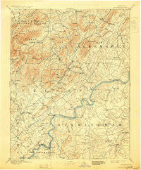
~ Buckingham VA topo map, 1:125000 scale, 30 X 30 Minute, Historical, 1892, updated 1929
Buckingham, Virginia, USGS topographic map dated 1892.
Includes geographic coordinates (latitude and longitude). This topographic map is suitable for hiking, camping, and exploring, or framing it as a wall map.
Printed on-demand using high resolution imagery, on heavy weight and acid free paper, or alternatively on a variety of synthetic materials.
Topos available on paper, Waterproof, Poly, or Tyvek. Usually shipping rolled, unless combined with other folded maps in one order.
- Product Number: USGS-5303782
- Free digital map download (high-resolution, GeoPDF): Buckingham, Virginia (file size: 7 MB)
- Map Size: please refer to the dimensions of the GeoPDF map above
- Weight (paper map): ca. 55 grams
- Map Type: POD USGS Topographic Map
- Map Series: HTMC
- Map Verison: Historical
- Cell ID: 65072
- Scan ID: 188883
- Imprint Year: 1929
- Survey Year: 1888
- Datum: Unstated
- Map Projection: Polyconic
- Map published by United States Geological Survey
- Map Language: English
- Scanner Resolution: 600 dpi
- Map Cell Name: Buckingham
- Grid size: 30 X 30 Minute
- Date on map: 1892
- Map Scale: 1:125000
- Geographical region: Virginia, United States
Neighboring Maps:
All neighboring USGS topo maps are available for sale online at a variety of scales.
Spatial coverage:
Topo map Buckingham, Virginia, covers the geographical area associated the following places:
- Schuyler - Walkers Ford - Caskie - Sherando - Ramsey - Lakeview Heights - Katrine - Adial - Yogaville - Durrett Town - Axtell - Allens Creek - Brownton (historical) - Warminster - Southwood Estates Mobile Home Park - Gladstone - Old Mount Vinco - Alberene - Esmont - Colleen - Greenfield - Shipman - Tillmans - Bryant - Powell Corner - Howardsville - Lanes Ford - Manteo - Saint Joy - North Garden - Miran Forest - Onan - Hendersons Store - Kingswood - Arrington - Covesville - Tye River - Valmont Estates - Gullysville - Wingina - Alcoma - Arrowhead - Buffalo Springs - Bungletown - Mill Creek - Heards - Martins Store - Bent Creek - Ransons - Norwood - Poplar Flats - Smith Store - Oak Ridge - Totier Hills - Keene - Roseland - Crossroads - Five Forks - Woods Corner - Mount Torry Furnace - Riverville - Lawthorne Mill - Beech Grove - Mount Vinco - Nellysford - Grays Corner - Freshwater - Woods Mill - Twin Poplars - Ottoway - Warren - Camm - Gordon Crossing - Jonesboro - Glendower - Avon - Batesville - Old Dominion - New Glasgow - Buckingham - Lovingston - Wintergreen - Piedmont - Midway Mills - Roses Mill - Lodebar - Hatton - Centenary - Porters - Damon - Glenmore - Four Forks - Greenway - Elma - Faber - Mount Rush - Boiling Spring - Marshall Manor - Tapscott - Rockfish
- Map Area ID: AREA3837.5-79-78.5
- Northwest corner Lat/Long code: USGSNW38-79
- Northeast corner Lat/Long code: USGSNE38-78.5
- Southwest corner Lat/Long code: USGSSW37.5-79
- Southeast corner Lat/Long code: USGSSE37.5-78.5
- Northern map edge Latitude: 38
- Southern map edge Latitude: 37.5
- Western map edge Longitude: -79
- Eastern map edge Longitude: -78.5


