
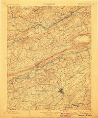
~ Bristol VA topo map, 1:125000 scale, 30 X 30 Minute, Historical, 1902, updated 1906
Bristol, Virginia, USGS topographic map dated 1902.
Includes geographic coordinates (latitude and longitude). This topographic map is suitable for hiking, camping, and exploring, or framing it as a wall map.
Printed on-demand using high resolution imagery, on heavy weight and acid free paper, or alternatively on a variety of synthetic materials.
Topos available on paper, Waterproof, Poly, or Tyvek. Usually shipping rolled, unless combined with other folded maps in one order.
- Product Number: USGS-5303760
- Free digital map download (high-resolution, GeoPDF): Bristol, Virginia (file size: 9 MB)
- Map Size: please refer to the dimensions of the GeoPDF map above
- Weight (paper map): ca. 55 grams
- Map Type: POD USGS Topographic Map
- Map Series: HTMC
- Map Verison: Historical
- Cell ID: 65058
- Scan ID: 188865
- Imprint Year: 1906
- Survey Year: 1895
- Datum: Unstated
- Map Projection: Unstated
- Map published by United States Geological Survey
- Map Language: English
- Scanner Resolution: 600 dpi
- Map Cell Name: Bristol
- Grid size: 30 X 30 Minute
- Date on map: 1902
- Map Scale: 1:125000
- Geographical region: Virginia, United States
Neighboring Maps:
All neighboring USGS topo maps are available for sale online at a variety of scales.
Spatial coverage:
Topo map Bristol, Virginia, covers the geographical area associated the following places:
- Bridwell Heights - Fugates Hill - Earheart (historical) - Deerfield Acres - Three Springs - Dwina - Castlewood - Lake Park - Counts - Hossan Heights - West Ridge - Barnett - Kiser (historical) - Hemlock - Nash Ford - Parsonage - Pondtown - Rural - Silica - Coeburn - Purcell - Candlewyck - Buncombe - Bristol - Big Creek (historical) - Oak Grove - Hilander Park - Flatwoods - Clinchfield - Carterton - Sunny Hills - Riverview - Fishdam (historical) - Sunny Brook - Haskell - Little Duck - Rocktown - Stone Bruise - Indian Hills - Parkwood Estates - Phillip - Rock City - Tumbez - South Clinchfield - Edgemont - Snowflake - Willis - Dante - Colonial Heights - Fractionville - Fullers - Coulwood - Painter Spring - Springdale - Dorado - Holston Hills - Boody - Paperville - Driftwood - Grandview Terrace - Oak Hill - Ketron - Dickensonville - Leonardtown - Lebanon - Belle Meadows - Hansonville - Tennessee Hills - Weaver - Grizzle (historical) - Greendale - Valley Hills - Evergreen Hills - Dickenson Corner - Mongle Spring - Vicco - Bondtown - Dry Fork - Oakview - Shelleys - Kingsley Hills - Holston - Bloomingdale - Hazel - Bristol - Shakesville - Pine (historical) - Sunrise Valley - Marlyn Hills - Maple Hill - Candler - Lawson (historical) - Rust Hollow - Bruno - Ravens Nest - Gunnings - Benhams - Rush Corner - Head of Linefork (historical) - Lime Hill
- Map Area ID: AREA3736.5-82.5-82
- Northwest corner Lat/Long code: USGSNW37-82.5
- Northeast corner Lat/Long code: USGSNE37-82
- Southwest corner Lat/Long code: USGSSW36.5-82.5
- Southeast corner Lat/Long code: USGSSE36.5-82
- Northern map edge Latitude: 37
- Southern map edge Latitude: 36.5
- Western map edge Longitude: -82.5
- Eastern map edge Longitude: -82


