
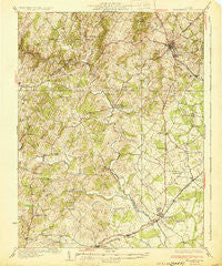
~ Warrenton VA topo map, 1:62500 scale, 15 X 15 Minute, Historical, 1930
Warrenton, Virginia, USGS topographic map dated 1930.
Includes geographic coordinates (latitude and longitude). This topographic map is suitable for hiking, camping, and exploring, or framing it as a wall map.
Printed on-demand using high resolution imagery, on heavy weight and acid free paper, or alternatively on a variety of synthetic materials.
Topos available on paper, Waterproof, Poly, or Tyvek. Usually shipping rolled, unless combined with other folded maps in one order.
- Product Number: USGS-5303554
- Free digital map download (high-resolution, GeoPDF): Warrenton, Virginia (file size: 9 MB)
- Map Size: please refer to the dimensions of the GeoPDF map above
- Weight (paper map): ca. 55 grams
- Map Type: POD USGS Topographic Map
- Map Series: HTMC
- Map Verison: Historical
- Cell ID: 64248
- Scan ID: 188707
- Woodland Tint: Yes
- Survey Year: 1927
- Datum: NAD
- Map Projection: Polyconic
- Map published by United States Geological Survey
- Map Language: English
- Scanner Resolution: 600 dpi
- Map Cell Name: Warrenton
- Grid size: 15 X 15 Minute
- Date on map: 1930
- Map Scale: 1:62500
- Geographical region: Virginia, United States
Neighboring Maps:
All neighboring USGS topo maps are available for sale online at a variety of scales.
Spatial coverage:
Topo map Warrenton, Virginia, covers the geographical area associated the following places:
- Elkwood - Deerfield Estates - Countryside Estates - Bealeton - Old Conde - Covingtons Corner - Marsh Run Mobile Home Park - Catalpa - South Wales - Meetze - Botha - Remington - Weaverville - Alwington - Churchill - Turnbull - Rixeyville - Amissville - Hurleyville - Oakshade - Mandleys Corner - Lakota - Carolandville - Opal - Warrenton - Waterloo - Doddstown - Brandy Station - Cliff Mills - Alanthus - Oak Shade - Frytown - Dudie - Lousetown - Perrowville - Litchfield - Magee - Palmers Crossroads - Ridgelea - Sunny Knoll - Liberty - Fayettesville - Jeffersonton - Erinbrook
- Map Area ID: AREA38.7538.5-78-77.75
- Northwest corner Lat/Long code: USGSNW38.75-78
- Northeast corner Lat/Long code: USGSNE38.75-77.75
- Southwest corner Lat/Long code: USGSSW38.5-78
- Southeast corner Lat/Long code: USGSSE38.5-77.75
- Northern map edge Latitude: 38.75
- Southern map edge Latitude: 38.5
- Western map edge Longitude: -78
- Eastern map edge Longitude: -77.75


