
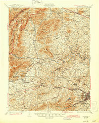
~ University VA topo map, 1:62500 scale, 15 X 15 Minute, Historical, 1931, updated 1944
University, Virginia, USGS topographic map dated 1931.
Includes geographic coordinates (latitude and longitude). This topographic map is suitable for hiking, camping, and exploring, or framing it as a wall map.
Printed on-demand using high resolution imagery, on heavy weight and acid free paper, or alternatively on a variety of synthetic materials.
Topos available on paper, Waterproof, Poly, or Tyvek. Usually shipping rolled, unless combined with other folded maps in one order.
- Product Number: USGS-5303494
- Free digital map download (high-resolution, GeoPDF): University, Virginia (file size: 11 MB)
- Map Size: please refer to the dimensions of the GeoPDF map above
- Weight (paper map): ca. 55 grams
- Map Type: POD USGS Topographic Map
- Map Series: HTMC
- Map Verison: Historical
- Cell ID: 63934
- Scan ID: 188653
- Imprint Year: 1944
- Survey Year: 1928
- Datum: NAD
- Map Projection: Polyconic
- Map published by United States Geological Survey
- Map Language: English
- Scanner Resolution: 600 dpi
- Map Cell Name: University
- Grid size: 15 X 15 Minute
- Date on map: 1931
- Map Scale: 1:62500
- Geographical region: Virginia, United States
Neighboring Maps:
All neighboring USGS topo maps are available for sale online at a variety of scales.
Spatial coverage:
Topo map University, Virginia, covers the geographical area associated the following places:
- Langford - Wilhait - Ednam Village - Ednam Forest - Reynard Woods - Mallard Lake - Bellair - Wyngate - Blue Ridge View - Davis Shop - Inglecress - Country Green - Laurel Hills - Arbor Park - Whispering Pines - Crozet - Decca (historical) - Queen Charlotte - Meriwether Hill - Crossroads - Patterson Store - Brinnington - Clearview Knolls - Barracks - Whipporwill Hollow - Sherwood Farms - Montvue - Loch Leigh - Huntington Village - Colthurst - Oak Hill - Clearview Meadows - Liberty Hill - Brownsville - Georgetown Green - Parkview - Westover Hills - University Heights - Logan Village - Windrift - Ballard Woods - Nob Hill - Glenaire - Canterbury Hills - Thurston - Ivy - Country View - Stadium Road Residence Area - Ednam - Brookwood - Cedarmere - Broad Axe (historical) - Foothill Village - Waverly - Boonesville - Farmington - Sherwood Manor - Knollwood - Lewis Hill East - Mountfair - White Hall - Ivy Farms - Peacock Hill - Stillfield - Hickory Ridge - Midway - Free Union - Ivy Ridge - The Meadows - Buckingham Circle - Owensville - Wayland Park - Ivy Woods - Orchard Acres - Beaver Hill Mobile Home Park - Fairgrove - West Leigh - Mill Ridge - Oak Hill Mobile Home Park - Freetown - Alderman Road Houses - Nortonsville - Hessian Hills - Lewis Hill West - Yancey Mills - Blueridge Forest - Sneads Mobile Home Park - Doylesville - West Woods - Ivy Oaks - Flordon - Skyline Crest - McCormick Road Houses - Millington - Candlewyck - Ivy Meadows
- Map Area ID: AREA38.2538-78.75-78.5
- Northwest corner Lat/Long code: USGSNW38.25-78.75
- Northeast corner Lat/Long code: USGSNE38.25-78.5
- Southwest corner Lat/Long code: USGSSW38-78.75
- Southeast corner Lat/Long code: USGSSE38-78.5
- Northern map edge Latitude: 38.25
- Southern map edge Latitude: 38
- Western map edge Longitude: -78.75
- Eastern map edge Longitude: -78.5


