
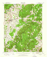
~ Stony Man VA topo map, 1:62500 scale, 15 X 15 Minute, Historical, 1929, updated 1962
Stony Man, Virginia, USGS topographic map dated 1929.
Includes geographic coordinates (latitude and longitude). This topographic map is suitable for hiking, camping, and exploring, or framing it as a wall map.
Printed on-demand using high resolution imagery, on heavy weight and acid free paper, or alternatively on a variety of synthetic materials.
Topos available on paper, Waterproof, Poly, or Tyvek. Usually shipping rolled, unless combined with other folded maps in one order.
- Product Number: USGS-5303426
- Free digital map download (high-resolution, GeoPDF): Stony Man, Virginia (file size: 10 MB)
- Map Size: please refer to the dimensions of the GeoPDF map above
- Weight (paper map): ca. 55 grams
- Map Type: POD USGS Topographic Map
- Map Series: HTMC
- Map Verison: Historical
- Cell ID: 63013
- Scan ID: 188596
- Imprint Year: 1962
- Woodland Tint: Yes
- Survey Year: 1929
- Datum: NAD27
- Map Projection: Polyconic
- Map published by United States Geological Survey
- Map Language: English
- Scanner Resolution: 600 dpi
- Map Cell Name: Stony Man
- Grid size: 15 X 15 Minute
- Date on map: 1929
- Map Scale: 1:62500
- Geographical region: Virginia, United States
Neighboring Maps:
All neighboring USGS topo maps are available for sale online at a variety of scales.
Spatial coverage:
Topo map Stony Man, Virginia, covers the geographical area associated the following places:
- Vaughn - Oak Hill - Blaineville - Marksville - Morning Star - Fairview - Fourway - Woodland Park - Westlu - Big Spring - Hilldale - Luray - Skyland - Stony Man - Valleyburgh - Oldrag (historical) - Ida - Oldrag - Etlan - Nethers - Big Meadows - Spring View - Forest Hills - Mauck - Brookside - Kimball - Springfield - Cavetown - Pine Grove
- Map Area ID: AREA38.7538.5-78.5-78.25
- Northwest corner Lat/Long code: USGSNW38.75-78.5
- Northeast corner Lat/Long code: USGSNE38.75-78.25
- Southwest corner Lat/Long code: USGSSW38.5-78.5
- Southeast corner Lat/Long code: USGSSE38.5-78.25
- Northern map edge Latitude: 38.75
- Southern map edge Latitude: 38.5
- Western map edge Longitude: -78.5
- Eastern map edge Longitude: -78.25


