
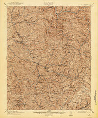
~ Bucu VA topo map, 1:62500 scale, 15 X 15 Minute, Historical, 1916, updated 1944
Bucu, Virginia, USGS topographic map dated 1916.
Includes geographic coordinates (latitude and longitude). This topographic map is suitable for hiking, camping, and exploring, or framing it as a wall map.
Printed on-demand using high resolution imagery, on heavy weight and acid free paper, or alternatively on a variety of synthetic materials.
Topos available on paper, Waterproof, Poly, or Tyvek. Usually shipping rolled, unless combined with other folded maps in one order.
- Product Number: USGS-5302626
- Free digital map download (high-resolution, GeoPDF): Bucu, Virginia (file size: 12 MB)
- Map Size: please refer to the dimensions of the GeoPDF map above
- Weight (paper map): ca. 55 grams
- Map Type: POD USGS Topographic Map
- Map Series: HTMC
- Map Verison: Historical
- Cell ID: 51885
- Scan ID: 187868
- Imprint Year: 1944
- Survey Year: 1914
- Datum: NAD
- Map Projection: Polyconic
- Map published by United States Geological Survey
- Map Language: English
- Scanner Resolution: 600 dpi
- Map Cell Name: Bucu
- Grid size: 15 X 15 Minute
- Date on map: 1916
- Map Scale: 1:62500
- Geographical region: Virginia, United States
Neighboring Maps:
All neighboring USGS topo maps are available for sale online at a variety of scales.
Spatial coverage:
Topo map Bucu, Virginia, covers the geographical area associated the following places:
- Bucu - Prater - Davenport - Jahile - Tiny - Duty - Vansant - Flatwoods - Rasnake - Venia - Fuller Corner - Hanger - Judge (historical) - Janey - Deel - Oakwood - Bee - Viers - Carrie - Colley - Indian (historical) - Leemaster - Skeggs - Cannady - Rowe - Council - Murphy - Vicey - Mount Heron - Laurel (historical) - Mavisdale - Wilder (historical) - Deskins
- Map Area ID: AREA37.2537-82.25-82
- Northwest corner Lat/Long code: USGSNW37.25-82.25
- Northeast corner Lat/Long code: USGSNE37.25-82
- Southwest corner Lat/Long code: USGSSW37-82.25
- Southeast corner Lat/Long code: USGSSE37-82
- Northern map edge Latitude: 37.25
- Southern map edge Latitude: 37
- Western map edge Longitude: -82.25
- Eastern map edge Longitude: -82


