
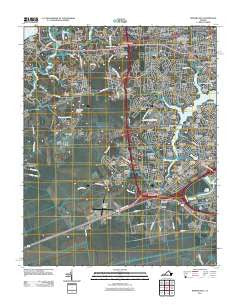
~ Bowers Hill VA topo map, 1:24000 scale, 7.5 X 7.5 Minute, Historical, 2011
Bowers Hill, Virginia, USGS topographic map dated 2011.
Includes geographic coordinates (latitude and longitude). This topographic map is suitable for hiking, camping, and exploring, or framing it as a wall map.
Printed on-demand using high resolution imagery, on heavy weight and acid free paper, or alternatively on a variety of synthetic materials.
Topos available on paper, Waterproof, Poly, or Tyvek. Usually shipping rolled, unless combined with other folded maps in one order.
- Product Number: USGS-5271762
- Free digital map download (high-resolution, GeoPDF): Bowers Hill, Virginia (file size: 20 MB)
- Map Size: please refer to the dimensions of the GeoPDF map above
- Weight (paper map): ca. 55 grams
- Map Type: POD USGS Topographic Map
- Map Series: US Topo
- Map Verison: Historical
- Cell ID: 5054
- Datum: North American Datum of 1983
- Map Projection: Transverse Mercator
- Map Cell Name: Bowers Hill
- Grid size: 7.5 X 7.5 Minute
- Date on map: 2011
- Map Scale: 1:24000
- Geographical region: Virginia, United States
Neighboring Maps:
All neighboring USGS topo maps are available for sale online at a variety of scales.
Spatial coverage:
Topo map Bowers Hill, Virginia, covers the geographical area associated the following places:
- Wynnewood - Siesta Gardens - Bruce - Jolliff - Simonsdale - Manning Estates - Berwyn - Sunray - Forest Hills - Arbor Meadows - Taylorwood Estates - Sandy Pines - Pride Homes - Green Lakes - Jester Gardens - Drum Creek Farms - Willow Lakes - Stone Bridge - Westwood - Davids Mill - Edgewood Park - Cedar Point - Raleigh Place - Armistead Forest - Briarwood - Wedgewood - Nansemond Shores - Woodbine - Belvedere - Churchland - Jolliff Woods - Green Meadow Point - Milteer Acres - Churchland West - Wetsmoreland - Holiday Point Estates - Colonial Point - Ames Cove - Cedar Grove Acres - Deerfield - Sterling Point - Huntersville - Holly Cove - Berwyn - Ahoy Shores - Hodges Manor - Glenmoore - Manor View - Belleville Meadows - Arbor Meadows - Silverwood - Dayle Acres - Algren - Wonderland Forest - Milteer Acres - Ames Cove - West Park Homes - Colony Manor - Hatton Point - Hodges Ferry - Pine Acres - South Dockwood - Dockwood - Bowers Hill - Shorewood - Bennett Creek - Bullocks Trailer Park - Belleville - Charlton Village - Deanes - Stewart Manor - Boone - Sweetbrier - Pughsville - Portsmouth Acres - Point Elizabeth - Mayflower Park - Riverbend - West Park Manor - Lamper Place - Chadswyck - Scotfield - Belleville Meadows - Park Manor - Elizabeth Acres - Green Acres - Glen Forest - Greenfield Farms - Ahoy Acres - Shoulders Hill - Dunedin - Elizabeth Manor
- Map Area ID: AREA36.87536.75-76.5-76.375
- Northwest corner Lat/Long code: USGSNW36.875-76.5
- Northeast corner Lat/Long code: USGSNE36.875-76.375
- Southwest corner Lat/Long code: USGSSW36.75-76.5
- Southeast corner Lat/Long code: USGSSE36.75-76.375
- Northern map edge Latitude: 36.875
- Southern map edge Latitude: 36.75
- Western map edge Longitude: -76.5
- Eastern map edge Longitude: -76.375


