
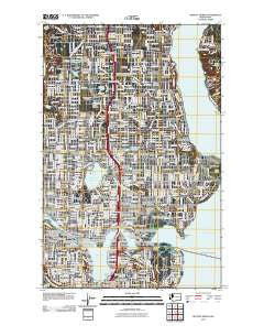
~ Seattle North WA topo map, 1:24000 scale, 7.5 X 7.5 Minute, Historical, 2011
Seattle North, Washington, USGS topographic map dated 2011.
Includes geographic coordinates (latitude and longitude). This topographic map is suitable for hiking, camping, and exploring, or framing it as a wall map.
Printed on-demand using high resolution imagery, on heavy weight and acid free paper, or alternatively on a variety of synthetic materials.
Topos available on paper, Waterproof, Poly, or Tyvek. Usually shipping rolled, unless combined with other folded maps in one order.
- Product Number: USGS-5256749
- Free digital map download (high-resolution, GeoPDF): Seattle North, Washington (file size: 19 MB)
- Map Size: please refer to the dimensions of the GeoPDF map above
- Weight (paper map): ca. 55 grams
- Map Type: POD USGS Topographic Map
- Map Series: US Topo
- Map Verison: Historical
- Cell ID: 40400
- Datum: North American Datum of 1983
- Map Projection: Transverse Mercator
- Map Cell Name: Seattle North
- Grid size: 7.5 X 7.5 Minute
- Date on map: 2011
- Map Scale: 1:24000
- Geographical region: Washington, United States
Neighboring Maps:
All neighboring USGS topo maps are available for sale online at a variety of scales.
Spatial coverage:
Topo map Seattle North, Washington, covers the geographical area associated the following places:
- Briarcrest - Wedgwood - Ronald - Broadview - Maple Leaf - Whittier Heights - Briercrest - Paramount Park - Laurelhurst - Pinehurst - Queen Anne - University Village - North Park - Matthews Beach - Bryant - Portage Bay - Montlake - Broadway - The Highlands - Chelsea - Foy - Sand Point - North College Park - Madison Park - Phinney Ridge - Edgewater (historical) - View Ridge - Latona (historical) - Lake City - Windermere - Meridian - Victory Heights - University - Ridgecrest - North Broadway - Northgate - Fremont - Parkwood - Lavilla - Hawthorne Hills - Meadowbrook - Wallingford - West Woodland - Manitou - Haller Lake - University District - Edgewater Park - Pontiac - Green Lake - Stevens - Jensen Trailer Mobile Home Court - Ross (historical) - Bella Mobile Home Park - Sheridan Beach - Halcyon Mobile Home Park - Cedar Park - Roosevelt - Olympic Hills - Morningside - Ravenna - Spring Beach - Kenwood - Broadmoor - Bitter Lake - Greenwood - Evergreen
- Map Area ID: AREA47.7547.625-122.375-122.25
- Northwest corner Lat/Long code: USGSNW47.75-122.375
- Northeast corner Lat/Long code: USGSNE47.75-122.25
- Southwest corner Lat/Long code: USGSSW47.625-122.375
- Southeast corner Lat/Long code: USGSSE47.625-122.25
- Northern map edge Latitude: 47.75
- Southern map edge Latitude: 47.625
- Western map edge Longitude: -122.375
- Eastern map edge Longitude: -122.25


