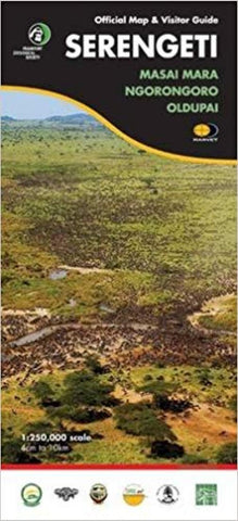
Serengeti Official Map and Visitor Guide, Oldupai Gorge, Masai Mara, Ngorongoro
This excellent map covers Serengeti National Park plus the adjoining protected areas of Northern Tanzania and across the border in Kenya, covering the whole of the Greater Serengeti Ecosystem. It is a large, detailed map with enlargements and extensive informative text on various aspects of the area, produced by Harvey Maps in cooperation with the Frankfurt Zoological Society, Tanzania National Parks and other environmental and academic organizations. The map has 100m contours with color tinting to show different types of vegetation: grassland, savannah, open and dense woodland. Permanent or seasonal rivers, lakes and pools, marshes and kopjes are shown and symbols mark locations of entrance gates, airstrips, lodges and campsites, ranger posts, tourist information centers and fuel supplies. Local roads and seasonal tracks have intermediate distances marked. The map has a UTM grid, plus latitude and longitude margin ticks at 30 intervals. The reverse side has extensive text, photograph
- Product Number: HAR_SEREN_19
- Reference Product Number: - None -
- ISBN: 9781851374045
- Date of Publication: 6/1/2019
- Folded Size: 6.69 inches high by 9.45 inches wide
- Unfolded (flat) Size: 18.9 inches high by 27.17 inches wide
- Map format: Folded
- Map type: Trade Maps - Hiking
- Geographical region: Tanzania