
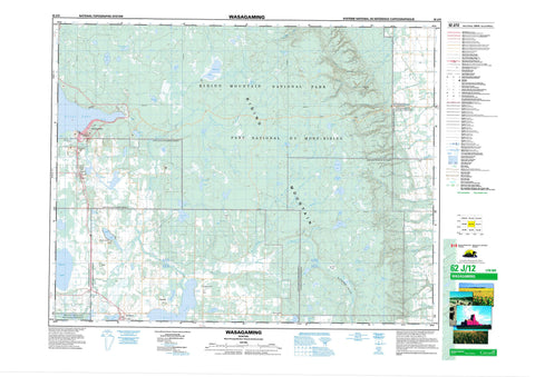
062J12 Wasagaming Canada topo map, 1:50,000 scale
062J12 Wasagaming NRCAN topographic map.
Includes UTM and GPS geographic coordinates (latitude and longitude). This 50k scale map is suitable for hiking, camping, and exploring, or you could frame it as a wall map.
Printed on-demand using high resolution, on heavy weight and acid free paper, or as an upgrade on a variety of synthetic materials.
Topos available on paper, Waterproof, Poly, or Tyvek. Usually shipping rolled, unless combined with other folded maps in one order.
- Product Number: NRCAN-062J12
- Parent Topo: TOPO-062J
- Map ID also known as: 062J12, 62J12
- Unfolded Size: Approximately 26" high by 36" wide
- Weight (paper map): ca. 55 grams
- Map Type: POD NRCAN Topographic Map
- Map Scale: 1:50,000
- Geographical region: Manitoba, Canada
Neighboring Maps:
All neighboring Canadian topo maps are available for sale online at 1:50,000 scale.
Purchase the smaller scale map covering this area: Topo-062J
Spatial coverage:
Topo map sheet 062J12 Wasagaming covers the following places:
- Deep Bay - Kuyp Drain - Norgate Drain - Reeve Drain - Rolling River 67 - Rolling River 67a - Apple Lake - Baraniuks Lake - Beaver Lodge Lake - Campbell Lake - Carson Lake - Clear Lake - Cowan Lake - Crescent Lake - Ditch Lake - East Deep Lake - Eleven Lake - Falcon Lake - Gertrude Lake - Helen Lake - Hemingston Lakes - Hemmingson Lakes - Huttons Lake - Josepha Lake - Katherine Lake - Kerr Lake - Kerrs Lake - Kidney Lake - Kinosao Lake - Lake Three - Leda Lake - Lees Lake - May Lake - McKinnon Lake - Ministic Lake - Muskrat Lake - North Pacey Lake - Octopus Lake - Otter Lake - Palser Lake - Pots Lake - Proven Lake - Pudge Lake - Rowland Lake - Salt Lake - Sand Lake - South Pacey Lake - Stink Lake - Watson Lake - Whirlpool Lake - Winslow Lake - Bald Hill - Little Bald Hill - Palser Hill - Riding Mountain - Wickdahls Hill - Clanwilliam - Harrison - McCreary - Rosedale - Lieu historique national du Canada du Centre-d'Inscription-de-l'Entrée-Est-du-Parc-du-Mont-Riding - Onanole Wildlife Management Area - Otter Lake Wildlife Management Area - Parc national du Canada du Mont-Riding - Proven Lake Wildlife Management Area - Riding Mountain National Park of Canada - Riding Mountain Park East Gate Registration Complex National Historic Site of Canada - Six Forty Plain - Bald Hill Creek - Birnie Creek - Conway Creek - Dead Ox Creek - Ferris Creek - Gorge Creek - Kinch Creek - McKinnon Creek - McLung Creek - Muskrat Creek - North Snake Creek - Octopus Creek - Packhorse Creek - Rolling River - Rolling River - Rowland Creek - South Bald Hill Creek - Swanson Creek - Tea Creek - Watson Creek - Whirlpool River - Wilson Creek - Otter Lake Springs - Erickson - Bethel - Ditch Lake - Kerr Lake - Kerrs Lake - Onanole - Scandinavia - Wasagaming - McFadden Valley - Hay Meadow - Ominnik Marsh


