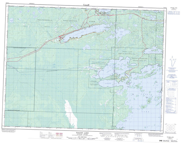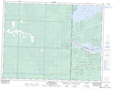
052E06 Berry Point Canada topo map, 1:50,000 scale
052E06 Berry Point NRCAN topographic map.
Includes UTM and GPS geographic coordinates (latitude and longitude). This 50k scale map is suitable for hiking, camping, and exploring, or you could frame it as a wall map.
Printed on-demand using high resolution, on heavy weight and acid free paper, or as an upgrade on a variety of synthetic materials.
Topos available on paper, Waterproof, Poly, or Tyvek. Usually shipping rolled, unless combined with other folded maps in one order.
- Product Number: NRCAN-052E06
- Parent Topo: TOPO-052E
- Map ID also known as: 052E06, 52E6, 52E06
- Unfolded Size: Approximately 26" high by 36" wide
- Weight (paper map): ca. 55 grams
- Map Type: POD NRCAN Topographic Map
- Map Scale: 1:50,000
- Geographical region: Manitoba, Canada
Neighboring Maps:
All neighboring Canadian topo maps are available for sale online at 1:50,000 scale.
Purchase the smaller scale map covering this area: Topo-052E
Spatial coverage:
Topo map sheet 052E06 Berry Point covers the following places:
- Calm Bay - Moosin Bay - Northwest Angle Inlet - Northwest Angle Inlet - Berry Point - Berry Point - Elmo Point - Northwest Point - Northwest Angle 33B - Northwest Angle 34C - Northwest Angle 34C & 37B - Northwest Angle 37C - Northwest Angle Indian Reserve 33B - Northwest Angle Indian Reserve 34C & 37B - Réserve indienne Northwest Angle 33B - Réserve indienne Northwest Angle 34C & 37B - Réserve indienne Shoal Lake 31J - Réserve indienne Shoal Lake 34B1 - Réserve indienne Shoal Lake 37A - Réserve indienne Shoal Lake 39 - Shoal Lake 31J - Shoal Lake 34B1 - Shoal Lake 37A - Shoal Lake 37A - Shoal Lake 39 - Shoal Lake 39 - Shoal Lake Indian Reserve 31J - Shoal Lake Indian Reserve 34B1 - Shoal Lake Indian Reserve 37A - Shoal Lake Indian Reserve 39 - Black Fox Islands - Boucher Island - Elmo Island - Mackey Island - Stull Island - Lac des Bois - Lake of the Woods - Shoal Lake - Shoal Lake - Sprague Lake - Twin Lakes - Whitemouth Pond - Northwest Angle Provincial Forest - Manitoba - Harrison Creek - Northwest Angle Creek - Poplar Creek - Powawassan Creek - Stony Creek - Northwest Point