
Yosemite Southeast, Ansel Adams Wilderness, Map 309
• Waterproof • Tear-Resistant • Topographic Map
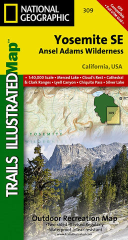
National Geographic’s Trails Illustrated map of Yosemite SE delivers extensive detail and valuable information to assist you in your exploration of this breathtaking wilderness. Created in partnership with local land management agencies, this expertly researched map delivers unmatched detail and helpful information for experienced outdoor enthusiasts and casual visitors alike. Some of the key areas of interest included are Tuolomne Meadows; Garnet, Thousand Island, Tenaya and Merced lakes; Moraine Meadows; Quartz Mountain; and the Cathedral Range.
With miles of mapped trails including portions of the Pacific Crest and John Muir trails, this map can guide you off the beaten path and back again in some of the most stunning scenery in the Sierras. Trail mileage between intersections will help you choose the path that’s right for you. The Sierra Vista Scenic Byway is noted for those wishing to take in the scenery by car. Recreat
- Product Number: TI_YOS_SE_19
- Reference Product Number: - None -
- ISBN: 9781566954136
- Date of Publication: 6/1/2019
- Folded Size: 7.48 inches high by 3.94 inches wide
- Unfolded (flat) Size: 30.71 inches high by 21.26 inches wide
- Map format: Folded
- Map type: Trade Maps - Park
- Geographical region: United States
- Geographical subregion: California


