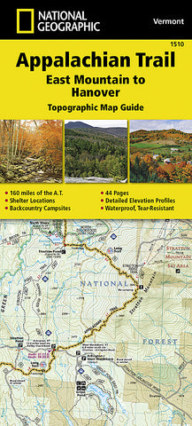
Appalachian Trail Topographic Map Guide, East Mountain to Hanover by National Geographic Maps
• Waterproof • Tear-Resistant • Topographic Map
The East Mountain to Hanover Topographic Map Guide makes a perfect traveling companion when traversing the Vermont section of the Appalachian Trail (A.T.). The landscape of Vermont is a variety of wooded mountains, forests of white pine and paper birch, and rolling terrain dotted by fields and pastures. To the north and east, the A.T. crosses short, steep hills and overgrown farmlands that characterize the Connecticut River valley. Farther south is the rugged and rocky high country of the Green Mountains.
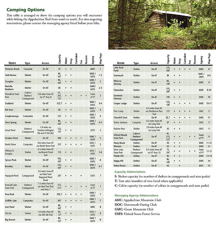
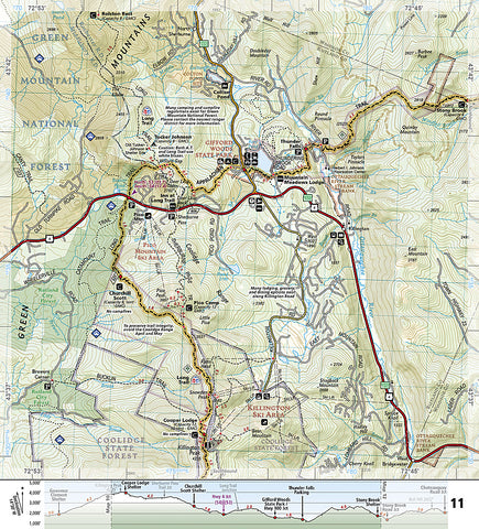
Each A.T. Topographic Map Guide includes detailed topographic maps at a detail of 1 inch = 1 mile. Each page is centered on the A.T. and overlaps with the adjacent pages so there is little chance of getting lost. Along the bottom of each page is a trail profile that shows the distance between shelters, camping areas, and trail access points. The map and trail profile provide a step by step visual guide to hiking the trail, mile by rugged mile. The Topographic Map Guide is built for all levels of hiking enthusiasts, from the day tripper to the multi month thru-hiker. The front pages of the printed Topographic Map Guide include resupply information, town inset maps, camping options, and much more.
Every Topographic Map Guide is printed on Backcountry Tough waterproof, tear-resistant paper. A full UTM grid is printed on the map to aid with GPS navigation.
Other features found on this map include: Bennington, Big Branch Shelter, Bromley Mountain, Bromley Shelter, Churchill Scott Shelter, Clarendon Shelter, Clarksburg State Forest, Congdon Shelter, Cooper Lodge Shelter, Glastenbury Mountain, Goddard Shelter, Governor Clement Shelter, Green Mountain National Forest, Greenwall Shelter, Hanover, Happy Hill Shelter, Kid Gore Shelter, Killington Peak, Lebanon, Little Rock Pond Shelter, Lost Pond Shelter, Manchester Center, Melville Nauheim Shelter, Minerva Hinchey Shelter, North Adams, Norwich, Peru Peak Shelter, Pico Camp Shelter, Rutland, Seth Warner Shelter, Spruce Peak Shelter, Stony Brook Shelter, Story Spring Shelter, Stratton Mountain, Stratton Pond Shelter, Thistle Hill Shelter, Velvet Rocks Shelter, Wallingford, White River Junction, William B. Douglas Shelter, Winturri Shelter, Woodstock.
- Product Number: 2209020B
- Product Code: TI_AT_1510
- Publisher Product ID: TI00001510
- ISBN: 9781597756471
- Year of Publication: 2015
- Unfolded Size: 9.45 x 4.33 inches
- Map type: Other
- Geographical region: United States