
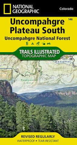
Uncompahgre Plateau, South, Map 146
• Waterproof • Tear-Resistant • Topographic Map
National Geographics Trails Illustrated map of Uncompahgre Plateau South is created for outdoor enthusiasts exploring the year-round recreational opportunities in this unique area in southwestern Colorado. Expertly researched and created in cooperation with the U.S. Forest Service, Bureau of Land Management and others, the map provides detail of southern Uncompahgre National Forest and River, Tabeguache and Roubideau Areas, Naturia Canyon, Wrights Mesa, Dan Noble and Dry Creek Basin State Wildlife Areas, San Miguel River and Canyon, Ridgway State Park and Tabeguache Trail.
Use the mapped trails, OHV routes and Forest Service roads to get off the beaten path and back on again while exploring the areas mesa and canyons. Trails are labeled according to their designated usage, whether exploring on foot, skis, horseback, mountain bike, motorcycle or ATV, including rock crawling trails. Additionally, both the Unaweep-Tabeguache
- Product Number: TI_UNCOM_PLAT_S_19
- Reference Product Number: - None -
- ISBN: 9781566955843
- Date of Publication: 6/1/2019
- Folded Size: 7.48 inches high by 3.94 inches wide
- Unfolded (flat) Size: 24.8 inches high by 36.22 inches wide
- Map format: Folded
- Map type: Trade Maps - Park
- Geographical region: United States
- Geographical subregion: Colorado


