
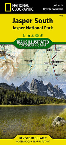
Jasper south : Jasper National Park
National Geographics Trails Illustrated map of Jasper South is a two-sided, waterproof map designed to meet the needs of outdoor enthusiasts with durability and detail.
The front side of the Jasper South map details the east side of the national park, from Whitehorse Wildland Provincial Park to the north, to White Goat Wilderness Area to the south. The reverse side of the map details the west side of the park, extending from Cummins Lakes Provincial Park to the south, to Victoria Cross Ranges to the North. Insets show survival tips, safe travel in Bear Country, and all the recreation the park has to offer with backpacking, camping, biking, hiking and horseback riding.
Trails Illustrated maps are expertly researched and frequently updated. The maps are printed in the United States on durable synthetic paper, making them waterproof, tear-resistant, and trail tough ? capable of going anywhere you do. The map is two-sided, and can be folded to a packable size of 4.25 x 9.25;
- Product Number: TI_JASPER_S_20
- Reference Product Number: - None -
- ISBN: 9781566956604
- Date of Publication: 6/1/2020
- Folded Size: 9.45 inches high by 4.33 inches wide
- Unfolded (flat) Size: 37.01 inches high by 24.8 inches wide
- Map format: Folded
- Map type: Trade Maps - Park
- Geographical region: Canada
- Geographical subregion: Alberta,British Columbia


