
Canyonlands National Park, Island in the Sky District, Map 310
• Waterproof • Tear-Resistant • Topographic Map
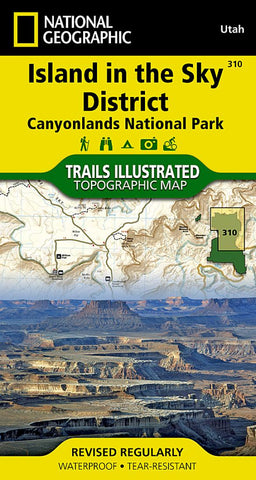
Of the four districts in Canyonlands National Park, the Island in the Sky District is the easiest district to visit in a short period of time. National Geographic’s Trails Illustrated map of Island in the Sky District combines extensive detail with helpful information to offer an invaluable tool for making the most of your visit to this extraordinary region. Created in partnership with local land management agencies, this expertly researched map features key areas of interest including White Rim Road; Green and Colorado rivers; Murphy Point; Stillwater and Labyrinth canyons; Grand View Point; and Dead Horse Point State Park.
The map base includes contour lines and elevations for summits. Trails and roads include mileage between intersections, and river mileage is noted as well for those exploring by boat. Road types are differentiated so you know if the route you choose is a four-wheel-drive or high-clearance road. Mountain
- Product Number: TI_ISLAND_21
- Reference Product Number: - None -
- ISBN: 9781566954600
- Date of Publication: 6/1/2021
- Folded Size: 7.48 inches high by 3.94 inches wide
- Unfolded (flat) Size: 36.61 inches high by 24.8 inches wide
- Map format: Folded
- Map type: Trade Maps - Park
- Geographical region: United States
- Geographical subregion: Utah


