
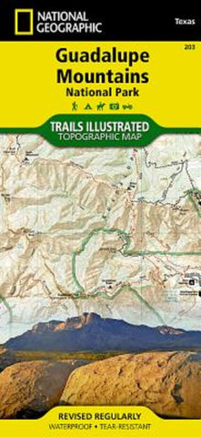
Guadalupe Mountains National Park, Map 203
• Waterproof • Tear-Resistant • Topographic Map
Created in cooperation with the National Park Service and others, National Geographic’s Trails Illustrated map of Guadalupe Mountains National Park is a complete travel guide to this pristine wilderness area. The map includes expertly researched information about the trees, shrubs, birds, amphibians and other flora and fauna that live in the the parks three ecosystems. The parks geologic history, which dates back nearly 300 million years, is explained as well.
Outdoor enthusiasts will be able to explore the area following precisely mapped trails, which include mileage markers and are color-coded according to their designated usage. Campgrounds, primitive campsites, picnic areas and points of interest along the trails are marked. To aid in your navigation of the area, the map also displays contour lines, elevations, labeled peaks, four-wheel drive and high clearance roads, water features and various waypoints. Additionally
- Product Number: TI_GUADALUPE_20
- Reference Product Number: - None -
- ISBN: 9781566953160
- Date of Publication: 6/1/2020
- Folded Size: 9.45 inches high by 4.33 inches wide
- Unfolded (flat) Size: 37.01 inches high by 24.8 inches wide
- Map format: Folded
- Map type: Trade Maps - Park
- Geographical region: United States
- Geographical subregion: Texas


