
Big Sur : Ventana Wilderness : Los Padres National Forest
• Waterproof • Tear-Resistant • Topographic Map
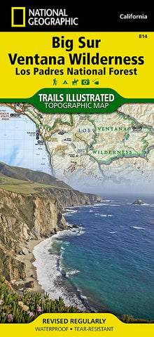
National Geographics Trails Illustrated map of Big Sur / Ventana Wilderness - Los Padres National Forest is a two-sided, waterproof map designed to meet the needs of outdoor enthusiasts with durability and detail. This map was created in conjunction with local land management agencies and is loaded with valuable recreation information.
The front side of Big Sur Ventana Wilderness map shows the south side of the area including Silver Peak Wilderness, Los Padres National Forest and Ventana Wilderness. The insets detail Ventana Wild Alliance, Los Padres National Forest, the US Forest Service campaign “Tread Lightly, California State Parks, California Coastal National Monument, California Coastal Trail, outdoor ethics, contact information, conservation easements and land trusts, Monument Bay National Marie Sanctuary, and travel management and vehicle use. The reverse side of the map show the north side of the area, including Mon
- Product Number: TI_BIG_SUR_22
- Reference Product Number: - None -
- ISBN: 9781566955782
- Date of Publication: 6/1/2022
- Folded Size: 9.45 inches high by 4.33 inches wide
- Unfolded (flat) Size: 37.01 inches high by 24.8 inches wide
- Map format: Folded
- Map type: Trade Maps - Park
- Geographical region: United States
- Geographical subregion: California


