
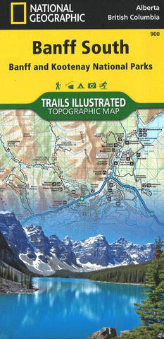
Banff South including Banff and Kootenay National Parks
• Waterproof • Tear-Resistant • Topographic Map
National Geographics Trails Illustrated map of Banff South delivers extensive detail for outdoor enthusiasts exploring the unparalleled mountain scenery and year-round recreational opportunities in the Canadian Rockies. Expertly researched and created in cooperation with Parks Canada and others, the map covers the southern and eastern areas of Banff National Park including popular points of interest Lake Minnewanka, Bow River, Johnston Canyon and the town of Banff. The map also covers Kootenay National Park; Scalp Creek Nature Area; Panther Corner, Dormer Sheep and Ghost PLUZs; Wild Horse and Red Deer River Recreation Areas; Height of the Rockies, Don Getty and Bow Valley Wildland Provincial Parks; Ghost River Wilderness Area; and Mount Assiniboine.
Explore the area by following the map to trailheads and then along precisely mapped trails, shown with distance markers in miles and kilometers and labeled for hiking, biking an
- Product Number: TI_BANFF_S_20
- Reference Product Number: - None -
- ISBN: 9781566956581
- Date of Publication: 6/1/2020
- Folded Size: 9.45 inches high by 4.33 inches wide
- Unfolded (flat) Size: 24.8 inches high by 37.01 inches wide
- Map format: Folded
- Map type: Trade Maps - Park
- Geographical region: Canada
- Geographical subregion: Alberta,British Columbia


