
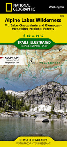
Alpine Lakes Wilderness, Washington, Map 825
• Waterproof • Tear-Resistant • Topographic Map
Outdoor enthusiasts looking to explore of the Central Cascades will find National Geographic’s Trails Illustrated map of Alpine Lakes Wilderness an indispensable tool. Expertly researched and created in partnership with the U.S. Forest Service and others, the map covers the wilderness and the surrounding parts of the Mt. Baker-Snoqualmie and Okanogan-Wenatchee National Forests. While the areas rugged, glacier-carved terrain is dominated by tens of peaks and hundreds of lakes, other key points of interest include Skykomish and Wenatchee River, Lake Eaton State Park and Stevens Pass.
All trails are clearly marked and color coded according to their designated usage, whether you’re traveling by foot, horse, mountain bike, or motorized vehicle. The Pacific Crest and Pacific Northwest Trails, which snake through the area, are highlighted. For those who prefer exploring in a motorized vehicle the Mountains to Sound and Stevens Pas
- Product Number: TI_ALPINE_20
- Reference Product Number: - None -
- ISBN: 9781566955072
- Date of Publication: 6/1/2020
- Folded Size: 9.45 inches high by 4.33 inches wide
- Unfolded (flat) Size: 24.8 inches high by 37.01 inches wide
- Map format: Folded
- Map type: Trade Maps - Park
- Geographical region: United States
- Geographical subregion: Washington


