
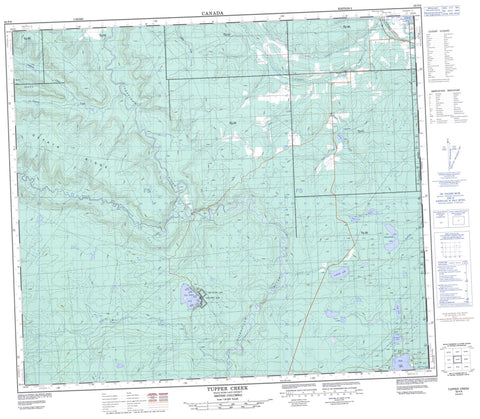
093P08 Tupper Creek Canada topo map, 1:50,000 scale
093P08 Tupper Creek NRCAN topographic map.
Includes UTM and GPS geographic coordinates (latitude and longitude). This 50k scale map is suitable for hiking, camping, and exploring, or you could frame it as a wall map.
Printed on-demand using high resolution, on heavy weight and acid free paper, or as an upgrade on a variety of synthetic materials.
Topos available on paper, Waterproof, Poly, or Tyvek. Usually shipping rolled, unless combined with other folded maps in one order.
- Product Number: NRCAN-093P08
- Parent Topo: TOPO-093P
- Map ID also known as: 093P08, 93P8, 93P08
- Unfolded Size: Approximately 26" high by 36" wide
- Weight (paper map): ca. 55 grams
- Map Type: POD NRCAN Topographic Map
- Map Scale: 1:50,000
- Geographical region: Alberta, Canada
Neighboring Maps:
All neighboring Canadian topo maps are available for sale online at 1:50,000 scale.
Purchase the smaller scale map covering this area: Topo-093P
Spatial coverage:
Topo map sheet 093P08 Tupper Creek covers the following places:
- Beaverlodge Lake - Cutbank Lake - Foster Lake - Gauthier Lake - Kelly Lake - Murray Lake - One Island Lake - Peavine Lake - Swan Lake - Teepee Lake - Twin Lakes - Oetata Ridge - Salt Hill - Salt Ridge - Peace River Regional District - One Island Lake Park - Albright Creek - Beaverlodge River - Bordet Creek - Cutbank Creek - Halfmoon Creek - Kiskatinaw River - Little Tupper Creek - Ministik Creek - Neumann Creek - Noel Creek - Oetata Creek - Peavine Creek - Steeprock Creek - Storie Creek - Tupper Creek - West Kiskatinaw River - West Peavine Creek - Kelly Lake - Jackson Slough


