
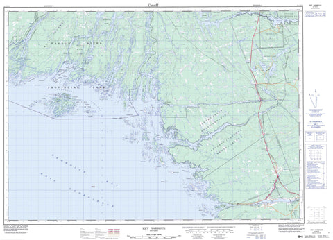
041H15 Key Harbour Canada topo map, 1:50,000 scale
041H15 Key Harbour NRCAN topographic map.
Includes UTM and GPS geographic coordinates (latitude and longitude). This 50k scale map is suitable for hiking, camping, and exploring, or you could frame it as a wall map.
Printed on-demand using high resolution, on heavy weight and acid free paper, or as an upgrade on a variety of synthetic materials.
Topos available on paper, Waterproof, Poly, or Tyvek. Usually shipping rolled, unless combined with other folded maps in one order.
- Product Number: NRCAN-041H15
- Parent Topo: TOPO-041H
- Map ID also known as: 041H15, 41H15
- Unfolded Size: Approximately 26" high by 36" wide
- Weight (paper map): ca. 55 grams
- Map Type: POD NRCAN Topographic Map
- Map Scale: 1:50,000
- Geographical region: Ontario, Canada
Neighboring Maps:
All neighboring Canadian topo maps are available for sale online at 1:50,000 scale.
Purchase the smaller scale map covering this area: Topo-041H
Spatial coverage:
Topo map sheet 041H15 Key Harbour covers the following places:
- Baie Georgienne - Beacon Rock Bay - Black Bay - Boulders Bay - Bowens Bay - Bustard Islands Harbour - Byng Inlet - David's Bay - Deep Bay - Fox Bay - Garbage Bay - Genessee Bay - Georgian Bay - Henvey Inlet - Key Bay - Key Harbour - Laramie Bay - Loading Cove - Macdougal Bay - Mill Pond Bay - Moose Bay - Moosehorn Bay - Muskrat Bay - Northeast Harbour - Otter Bay - Robinson's Bay - Sand Bay - Sand Bay - Sandy Bay - Scow Bay - Smith Bay - The Creek - The Flower Pot - The Key - Watts Bend - Whistler Bay - Whitefish Bay - Wilcox Cove - Bad River Point - Bend Point - Bluff Point - Cantin Point - Dokis Point - Gatacre Point - Kantos Point - Lamondin Point - Northeast Point - Pincer Point - Pine Tree Point - Pinetree Point - Potvin Point - South Point - The Elbow - Tramway Point - Bad River Channel - Badriver Channel - Canoe Channel - Coral Channel - Cross Channel - Cross Narrows - Cunninghams Channel - Davis Channel - Dead Island Channel - Eastern Outlet - Free Drinks Passage - French River Western Channel - Little Canoe Channel - Lodge Channel - Lovers Lane - North Channel - North Channel - Northeast Passage - Old Voyageur Channel - Parting Channel - Rabbit Narrows - Rogers Gut - The Five Fingers - The Gun Barrel - Twin Narrows - Voyageur Channel - Western Channel - Western Channel (French River) - Whale's Mouth - Wicks Channel - Devil Gap Falls - Herring Chute - Herring Chutes - Liley Chutes - Henvey - Mowat - Parry Sound - Struthers - Sudbury - Travers - Wallbridge - French River 13 - French River Indian Reserve 13 - Henvey Inlet 2 - Henvey Inlet Indian Reserve 2 - Magnetawan Indian Reserve 1 - Réserve indienne French River 13 - Réserve indienne Henvey Inlet 2 - Réserve indienne Magnetawan 1 - Ab Island - Bekanon Island - Beresford Island - Bigsby Island - Bigwood Island - Brock Island - Burnt Island - Burnt Island - Bustard Islands - Camp Island - Cantin Island - Cash Island - Castle Island - Cedar Island - Champlain Island - Cherry Island - Chimney Island - Churchill Islands - Clark Island - Clark Island - Clark Islands - Clark Islands - Clark Islands - Claw Island - Cunninghams Island - Dead Island - Depot Island - Dock Island - Doctor Oil Island - Doiron Island - Dokis Island - Dreavers Island - Fifteen Mile Island - Finger Island - Flat Island - Flowerpot Islands - Fourteen Mile Island - Fox Island - France Island - French River Island - Gateway Islands - Germain Island - Gladstone Island - Golden Sword Island - Gooseberry Island - Graburn Island - Green Island - Green Island - Gun Island - Hahn Island - Harbour Island - Henvey Islands - Herschel Island - Highland Home - Humbum Island - James Island - Keefer Island - Keefer Islands - King's Island - Lash Island - Lefroy Island - Lincoln Island - Lombiere Island - Long Island - Magee Island - Major Island - Mann Island - McDougal Island - Meaford Island - Merranger's Island - Mica Island - Northeast Island - Obstacle Island - Old Mill Island - One Tree Island - Outer Fox Islands - Pearl Island - Pine Island - Porcupine Island - Pratt Island - Puddick Island - Queenie Island - Rabbit Island - Ridout Islands - Rogers Island - Sabine Island - Salisbury Island - Silent Island - Strawberry Island - Tanvat Island - Tarpot Island - The Shirt Tails - Tie Island - Twin Islands - Umbrella Island - Vixen Island - Wedge Island - Windreach Island - Bass Lake - Bucke Lake - Burke Lake - Cantin Lake - Clear Lake - Fox Lake - Grundy Lake - Gurd Lake - Gut Lake - Lake Huron - Nisbet Lake - Pakeshkag Lake - Pike Lake - Portage Lake - Rock Lake - Straight Lake - Tower Lake - Trestle Gully Lake - Walter Lake - Rutherford and George Island - French River Provincial Park - Grundy Lake Provincial Park - Big Jameson Rapids - Crooked Rapids - Dalles Rapids - Devil Door Rapids - Devil Gap Rapids - Dorés Run - Little Jameson Rapids - Rogers Run - Bass Creek - Bekanon Creek - Black Creek - Dalles Creek - Eastern Outlet - Eastern Outlet (French River) - Fox Creek - French River - French River (Eastern Outlet) - French River (Main Outlet) - French River Eastern Outlet - Key River - Little Key River - Magnetawan River - Main Outlet - Main Outlet (French River) - Nisbet Creek - Pakeshkag River - Pickerel River - Rivière des Français - South Channel - Still River - Sucker Creek - Ab Shoal - Alwin Rock - Bagot Rock - Barclay Rock - Beacon Rock - Belize Rock - Bessener Rock - Black Rock - Borron Rock - Bray Reef - Britton Rock - Britton Shoal - Burke Shoal - Burton Bank - Bustard Rocks - Camel Rock - Camel Rocks - Cherokee Rock - Cherokee Rocks - Counts Bank - Cross Ledge - Dead Island Reef - Dingy Rock - Edsall Bank - Elgin Rock - Everard Reef - Flat Rock - Frances Smith Shoal - Goldwin Rock - Guano Rock - Gull Rocks - Hall Rock - Hanna Bank - Hardie Rock - Keystone Rock - Loaf Rock - Lynch Rock - Macoun Rock - Mary Grant Rock - McLean Shoal - McNab Rocks - Middle Reef - Minnie Rock - Murray Rocks - Northwest Bank - Ossifrage Rock - Perkins Rock - Perley Rock - Phillips Shoal - Pratt Reef - Queen Reef - Ruel Reef - Ruel Shoal - Seymour Rock - Sibald Rock - Solitary Rock - Southeast Rock - Southwest Rock - The Fingerboards - Turnaway Rock - Turning Rock - Wicksteed Rock - Zachary Rock - Killarney - Northeastern Manitoulin and the Islands - Bekanon - Britt - Britt Station - Byng Inlet - Byng Inlet North - Cranberry - Cranberry - Cranberry Lake - French River - Key Harbour - Key Junction - Key River - Ludgate - Pakesley - Pickerel - Still River - Wanikewin


