
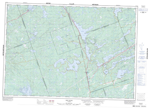
031C14 Bon Echo Canada topo map, 1:50,000 scale
031C14 Bon Echo NRCAN topographic map.
Includes UTM and GPS geographic coordinates (latitude and longitude). This 50k scale map is suitable for hiking, camping, and exploring, or you could frame it as a wall map.
Printed on-demand using high resolution, on heavy weight and acid free paper, or as an upgrade on a variety of synthetic materials.
Topos available on paper, Waterproof, Poly, or Tyvek. Usually shipping rolled, unless combined with other folded maps in one order.
- Product Number: NRCAN-031C14
- Parent Topo: TOPO-031C
- Map ID also known as: 031C14, 31C14
- Unfolded Size: Approximately 26" high by 36" wide
- Weight (paper map): ca. 55 grams
- Map Type: POD NRCAN Topographic Map
- Map Scale: 1:50,000
- Geographical region: Ontario, Canada
Neighboring Maps:
All neighboring Canadian topo maps are available for sale online at 1:50,000 scale.
Purchase the smaller scale map covering this area: Topo-031C
Spatial coverage:
Topo map sheet 031C14 Bon Echo covers the following places:
- Brown's Bay - Campbell Bay - Earls Bay - Echo Bay - German Bay - Green Bay - Hungry Bay - Jacques' Bay - Michell Bay - Snyder Bay - Watkin Bay - Washing Machine Point - The Narrows - Abinger - Anglesea - Barrie - Cashel - Clarendon - Effingham - Frontenac - Grimsthorpe - Hastings - Kaladar - Kennebec - Lennox and Addington - Miller - Big Bear Island - Big Island - Blake Island - Ikthoos Island - Michell Island - Snake Island - Abes Lake - Baudette Lake - Beech Lake - Benny's Lake - Big Gull Lake - Big McCaw Lake - Bishop Lake - Blind Lake - Blue Lake - Bon Echo Lake - Boundary Lake - Buck Lake - Buckshot Lake - Campbell Lake - Canniff Lake - Canoe Lake - Cedar Lake - Charlies Lake - Clarendon Lake - Cloyne Lake - Clutes Lake - Dafoe Lake - Dog Lake - Effingham Lake - Elbow Lake - Essens Lake - Feeny Lake - Georgia Lake - Green Lake - Grimsthorpe Lake - Hannah Lake - Hicks Lake - Hill Lake - Hills Lake - Horton Lake - Joeperry Lake - Kashwakamak Lake - Kerr Lake - Kilbourne Lake - Killer Lake - Kishkebus Lake - Lingham Lake - Little Bishop Lake - Little Green Lake - Little Long Lake - Little Marble Lake - Little McCaw Lake - Little Merrill Lake - Little Mink Lake - Little Mink Lake - Little Mississagagon Lake - Little Mud Lake - Little Rock Lake - Little Sanford Lake - Little Shabomeka Lake - Little Stoll Lakes - Long Mallory Lake - Lower Mazinaw Lake - Machesney Lake - Mackavoy Lake - Mallory Lake - Marble Lake - Mazinaw Lake - Mazinaw Lake - McCausland Lake - McDowall Lake - McNeils Lake - Merrill Lake - Minktrack Lake - Mississagagon Lake - Mitchell Lake - Morgan Lake - Muskrat Lake - Neal Lake - Nervine Lake - Norway Lake - Norway Lake - Partridge Lake - Pearson Lake - Plevna Lake - Pringle Lake - Quebec Lake - Rainy Lake - Reid Lakes - Rock Lake - Rockside Lake - Salmond Lake - Salmond Twin Lakes - Sand Lake - Semicircle Lake - Shabomeka Lake - Shaw Lake - Shawenegog Lake - Shedwick Lake - Sheldrake Lake - Shoepack Lake - Silva Lake - Skootamatta Lake - Slave Lake - Star Lake - Stoll Lake - Story Lake - Stringer Lake - Swamp Lake - Tamarack Lake - Tawny Pond - Tilney Lake - Tiny Shabomeka Lake - Todd Lakes - Tonawa Lake - Topper Lake - Turtle Lake - Twin Lake - Twin Lakes - Upper Mazinaw Lake - Upper Partridge Lake - Valhalla Lake - Walden Pond - Washes Lake - Weslemkoon Lake - Whitefish Lake - Wickware Lake - Woods Lake - Mazinaw Rock - Rekr Rock - Rock Candy Mountain - Frontenac - Hastings - Lennox and Addington - Addington Highlands - Barrie - Central Frontenac - Clarendon and Miller - Denbigh, Abinger and Ashby - Elzevir and Grimsthorpe - Hinchinbrooke - Hungerford - Kaladar, Anglesea and Effingham - Kennebec - North Frontenac - Olden - Oso - Palmerston and North and South Canonto - Tudor and Cashel - Tweed - Bon Echo Provincial Park - Kishkebus Lake Wilderness Area - Lingham Lake Conservation Reserve - Marble Rapids - Whitefish Rapids - Beaver Creek - Black River - Bon Echo Creek - Boundary Creek - Browns Creek - Buckshot Brook - Buckshot Creek - Burtchell Creek - Campbell Creek - Canniff Creek - Coburn Creek - Dead Creek - Elbow Lake Creek - Fraser Creek - Grant Creek - Killer Creek - Mallory Creek - Merrill Creek - Mississippi River - Muggs' Mud Creek - North Creek - Partridge Creek - Rainy Creek - Semicircle Creek - Shoepack Creek - Skootamata River - Skootamatta River - Stoll Creek - Story Creek - Swamp Creek - Valhalla Creek - Winter Road Creek - Wolf Creek - Old Walt Rock - Beech Corners - Bishop Corners - Bon Echo - Cloyne - Harlowe - Massanoga - McCrae - Myer Cave - Myers Cave - Weslemkoon - Humphrey Marsh


