
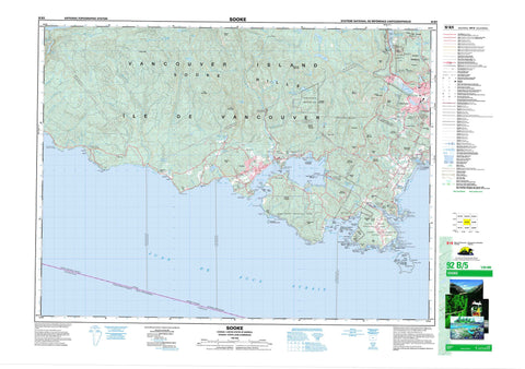
092B05 Sooke Canada topo map, 1:50,000 scale
092B05 Sooke NRCAN topographic map.
Includes UTM and GPS geographic coordinates (latitude and longitude). This 50k scale map is suitable for hiking, camping, and exploring, or you could frame it as a wall map.
Printed on-demand using high resolution, on heavy weight and acid free paper, or as an upgrade on a variety of synthetic materials.
Topos available on paper, Waterproof, Poly, or Tyvek. Usually shipping rolled, unless combined with other folded maps in one order.
- Product Number: NRCAN-092B05
- Parent Topo: TOPO-092B
- Map ID also known as: 092B05, 92B5, 92B05
- Unfolded Size: Approximately 26" high by 36" wide
- Weight (paper map): ca. 55 grams
- Map Type: POD NRCAN Topographic Map
- Map Scale: 1:50,000
- Geographical region: British Columbia, Canada
Neighboring Maps:
All neighboring Canadian topo maps are available for sale online at 1:50,000 scale.
Purchase the smaller scale map covering this area: Topo-092B
Spatial coverage:
Topo map sheet 092B05 Sooke covers the following places:
- Anderson Cove - Becher Bay - Campbell Bay - Campbell Cove - Cooper Cove - Finlayson Arm - Hutchinson Cove - Iron Mine Bay - Murder Bay - Orveas Bay - Parker Bay - Parry Bay - Pedder Bay - Quarantine Cove - Roche Cove - Saanich Inlet - Sooke Basin - Sooke Bay - Sooke Harbour - Sooke Inlet - Whirl Bay - French Beach - Gordons Beach - Weir Beach - Alldridge Point - Beechey Head - Billings Point - Billings Spit - Caffery Point - Cape Calver - Christie Point - Christopher Point - Church Point - Company Point - Creyke Point - Cudlip Point - Edye Point - Eliza Point - Fossil Point - George Point - Glacier Point - Goodridge Peninsula - Harrison Point - Helgesen Point - Hill Head - Hoskyn Point - Kellett Point - Lorimer Point - Manor Point - Muir Point - Ned Point - O'Brien Point - Otter Point - Parsons Point - Parsons Spit - Pim Head - Point Ash - Point No Point (Glacier Point) - Possession Point - Rocky Point - Saanich Peninsula - Sheringham Point - Simpson Point - Smyth Head - Trollope Point - Watt Point - Weir Point - Whiffin Spit - Whitney-Griffiths Point - William Head - Woodward Point - Yates Point - Florence Lake Cave - Détroit de Juan de Fuca - Eemdyk Passage - Juan de Fuca Strait - Race Passage - Colwood - Langford - Highlands - Metchosin - Sooke - Niagara Falls - Esquimalt Land District - Goldstream Land District - Highland Land District - Malahat Land District - Metchosin Land District - Otter Land District - Renfrew Land District - Sooke Land District - Becher Bay Indian Reserve 1 - Becher Bay Indian Reserve 2 - Fraser Island Indian Reserve 6 - Goldstream Indian Reserve 13 - Lamb Island Indian Reserve 5 - Long Neck Island Indian Reserve 9 - Réserve indienne 1 T'Sou-ke - Réserve indienne 2 T'Sou-ke - Réserve indienne Becher Bay 1 - Réserve indienne Becher Bay 2 - Réserve indienne Fraser Island 6 - Réserve indienne Goldstream 13 - Réserve indienne Lamb Island 5 - Réserve indienne Long Neck Island 9 - Réserve indienne Sooke 1 - Réserve indienne Sooke 2 - Réserve indienne T'Sou-ke 1 - Réserve indienne T'Sou-ke 2 - Réserve indienne Twin Island 10 - Réserve indienne Village Island 7 - Réserve indienne Whale Island 8 - Sooke Indian Reserve 1 - Sooke Indian Reserve 2 - T'Sou-ke Indian Reserve 1 - T'Sou-ke Indian Reserve 2 - Twin Island Indian Reserve 10 - Village Island Indian Reserve 7 - Whale Island Indian Reserve 8 - Arden Islet - Argyle Islet - Argyle Islets - Bedford Islands - Bentinck Island - Church Island - Cub Islets - Donaldson Island - Frazer Island - Gillespie Island - Goodridge Islands - Haystock Islets - Île de Vancouver - John Parker Islands - Lamb Island - Large Bedford Island - Little Church Island - North East Islets - Secretary (Donaldson) Island - Shelter Islands - South Bedford Island - South East Islets - South West Islets - Swordfish Island - Vancouver Island - Village Islands - West Bedford Island - Wolf Island - Wolfe Island - Bert Lake - Blinkhorn Lake - Boneyard Lake - Boulder Lake - Butler Lake - Crabapple Lake - Diversion Reservoir - Elliott Reservoir - Florence Lake - Forslund Lake - Glen Lake - Glinz Lake - Goldstream Lake - Grass Lake - Humpback Reservoir - Jack Lake - Kemp Lake - Langford Lake - Matheson Lake - Matson Lake - Mavis Lake - McKenzie Lake - Metchosin Lagoon - Old Wolf Lake - Peden Lake - Poirier Lake - Quarantine Lake - Ranger Lake - Sheilds Lake - Sherwood Lake - Sherwood Pond - Teanook Lake - Tugwell Lake - Witty's Lagoon - Young Lake - Bentinck Island Range - Champ de manoeuvre Mary Hill - Champ de manoeuvre Rocky Point - Champ de tir Île de Bentinck - Mary Hill Training Area - Rocky Point Training Area - Babbington Hill - Bluff Mountain - Broom Hill - Buck Hill - Camas Hill - Centre Mountain - Church Hill - Empress Mountain - Garibaldi Hill - Gowlland Range - Iron Mine Hill - Jack Mountain - Mary Hill - Metchosin Mountain - Middle Peak - Miles Hill - Miniskirt - Montreal Hill - Montreul Hill - Mount Ash - Mount Blinkhorn - Mount Braden - Mount Finlayson - Mount Jack - Mount Maguire - Mount Manuel Quimper - Mount Matheson - Mount McDonald - Mount Muir - Mount Wells - MountHelmcken - Muir Mountain - Ragged Mountain - Red Flag Mountain - Redflag Mountain - Single Hill - Skirt Mountain - Sooke Hills - South Rise Hill - Sugarloaf - Trap Mountain - Triangular Hill - Vancouver Island Mountains - Vancouver Island Ranges - Wells Mountain - Wolf Hill - Capital Regional District - French Beach Park - Goldstream Park - Langford Centennial Park - Matheson Lake Park - Sooke Mountain Park - Sooke Potholes Park - Dewdney Flats - British Columbia - Colombie-Britannique - Alligator Creek - Arbutus Creek - Ayum Creek - Barnes Creek - Begg Creek - Bilston Creek - Charters Creek - Charters River - Cole Creek - Colwood Creek - De Mamiel Creek - De Maniel Creek - Demaniel Creek - Desolation Creek - Doerr Creek - Eaglet Creek - Firehall Creek - Fisherman Creek - Frenchome Creek - Gillespie Creek - Goldstream River - Golledge Creek - Golledge River - Goudie Creek - Hewitt Creek - Jacob Creek - Jordan River - Kemp Stream - King Creek - Kirby Creek - Langford Creek - Lannon Creek - Leech River - Macdonald Creek - Mary Vine Creek - Metchosin Creek - Mill Stream - Mink Creek - Muir Creek - Niagara Creek - Old Wolf Creek - Orveas Creek - Parasite Creek - Pike Creek - Poirier Creek - Rockbottom Creek - Rough Creek - Sandcut Creek - Sandstone Creek - Saseenos Creek - Sherwood Creek - Sooke River - Swallow Creek - Todd Creek - Tugwell Creek - Veitch Creek - Vera Brook - Vye Creek - Waugh Creek - Wildwood Creek - Williamson Creek - Wolfe Creek - Anchor Rock - Grant Rocks - Great Race Rock - Kellett Reef - Middle Ground - North Race Rock - Race Rocks - Rosedale Rock - West Race Rocks - Albert Head - Bear Mountain - Braemar Heights - East Sooke - Glen Lake - Goldstream - Happy Valley - Langford Station - Leechtown - Luxton - Millstream - Milnes Landing - Milnes Landing - Otter Point - Rocky Point - Rocky Point - Saseenos - Shirley - William Head - Niagara Canyon - Skookum Gulch


