
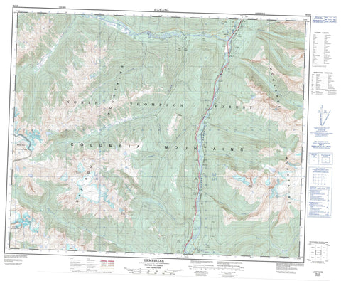
083D06 Lempriere Canada topo map, 1:50,000 scale
083D06 Lempriere NRCAN topographic map.
Includes UTM and GPS geographic coordinates (latitude and longitude). This 50k scale map is suitable for hiking, camping, and exploring, or you could frame it as a wall map.
Printed on-demand using high resolution, on heavy weight and acid free paper, or as an upgrade on a variety of synthetic materials.
Topos available on paper, Waterproof, Poly, or Tyvek. Usually shipping rolled, unless combined with other folded maps in one order.
- Product Number: NRCAN-083D06
- Parent Topo: TOPO-083D
- Map ID also known as: 083D06, 83D6, 83D06
- Unfolded Size: Approximately 26" high by 36" wide
- Weight (paper map): ca. 55 grams
- Map Type: POD NRCAN Topographic Map
- Map Scale: 1:50,000
- Geographical region: British Columbia, Canada
Neighboring Maps:
All neighboring Canadian topo maps are available for sale online at 1:50,000 scale.
Purchase the smaller scale map covering this area: Topo-083D
Spatial coverage:
Topo map sheet 083D06 Lempriere covers the following places:
- Howard Bay - Serpentine Névé - Moonbeam Lake - Paradise Lake - Cariboo Mountains - Columbia Mountains - Columbia System - Monashee Mountains - Mount Chappell - Mount Cheadle - Mount Netzel - Mount St. Anne - Premier Range - North Thompson Oxbows East Park - North Thompson Oxbows Manteau Park - Pyramid Creek Falls Park - Wells Gray Park - Adolph Creek - Albreda River - Bone Creek - Canvas Creek - Cedar Creek - Chappell Creek - Dominion Creek - Gravel Creek - Gum Creek - Lempriere Creek - Manteau Creek - Miledge Creek - Moonbeam Creek - North Blue River - North Thompson River - Oasis Creek - Pyramid Creek - Serpentine Creek - Switch Creek - Thunder River - Gosnell - Gosnell - Lempriere - Pyramid


