
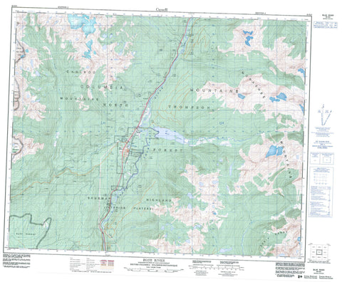
083D03 Blue River Canada topo map, 1:50,000 scale
083D03 Blue River NRCAN topographic map.
Includes UTM and GPS geographic coordinates (latitude and longitude). This 50k scale map is suitable for hiking, camping, and exploring, or you could frame it as a wall map.
Printed on-demand using high resolution, on heavy weight and acid free paper, or as an upgrade on a variety of synthetic materials.
Topos available on paper, Waterproof, Poly, or Tyvek. Usually shipping rolled, unless combined with other folded maps in one order.
- Product Number: NRCAN-083D03
- Parent Topo: TOPO-083D
- Map ID also known as: 083D03, 83D3, 83D03
- Unfolded Size: Approximately 26" high by 36" wide
- Weight (paper map): ca. 55 grams
- Map Type: POD NRCAN Topographic Map
- Map Scale: 1:50,000
- Geographical region: British Columbia, Canada
Neighboring Maps:
All neighboring Canadian topo maps are available for sale online at 1:50,000 scale.
Purchase the smaller scale map covering this area: Topo-083D
Spatial coverage:
Topo map sheet 083D03 Blue River covers the following places:
- Eleanor Lake - Jewel Lake - Mud Lake - Round Lake - Slide Lake - Surprise Lake - Columbia Mountains - Duffy Peaks - French Peaks - Hellroar Mountain - Monashee Mountains - Mount Cook - Mount Don Nelson - Mount Nelson - Parbury Ridge - Ptarmigan Mountain - Redsand Mountain - Shuswap Highland - Blue River - Black Spruce Park - Blue River Park - Blue River Pine Park - Mud Lake Delta Park - Wells Gray Park - Interior Plateau - Adams River - Berry Creek - Blue River - Bone Creek - Cedar Creek - Cook Creek - Finn Creek - Fleuve Fraser - Fraser River - Froth Creek - Goose Creek - Hellroar Creek - Macrae Creek - Mud Creek - North Blue River - North Thompson River - Peddie Creek - Smoke Creek - Storm Creek - Strait Creek - Thunder River - White River - Whitewater Creek - Wilkins Creek - Angus Horne - Angushorn - Blue River - Blue River East - Blue River West - Bungalow G - Redsand - Thunder River


